The Problems With Modern Exodus Red Sea Theories

The location of the Red Sea of the Exodus has been the subject of debate for many years. In the maps section of many Bibles, one may notice that the route marked on the map to the traditional Mount Sinai location frequently does not have the Israelites crossing any part of the Red Sea. However, there are significant problems with these modern Exodus Red Sea theories. We will analyze some of these issues on this page.
A Sea, Lake, or Marsh?
A common map of the Exodus looks something like this, with the Red Sea crossing appearing to be somewhere north of the Gulf of Suez (though the route lines often only touch these bodies of water and do not actually cross):
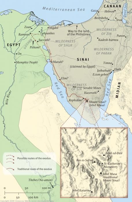
These common maps place the crossing point somewhere north of the Gulf of Suez at the Great Bitter Lake, Lake Timsah, or even further north in the Nile Delta region.
The theories of a Bitter Lake crossing or a Nile Delta crossing seem to have more weight because of the length of their existence rather than how they fit into the Exodus story.
In a documentary with Bob Cornuke and Larry Williams, who traveled to Jabal Maqla in 1988, Biblical Scholar and Professor Ken Durham states that if the Bitter Lake is where the Hebrews crossed the water, Pharaoh would have most certainly had his forces divided and sent to both sides of the lake to cut the Hebrews off.
However, as Josephus describes in Book II, chapter 15 of The Antiquities of the Jews, the sea was before the Israelites, mountains on the other sides, and Pharaoh's army behind them.
Now when the Egyptians had overtaken the Hebrews,they prepared to fight them, and by their multitude they drove them into a narrow place; for the number that pursued after them was six hundred chariots, with fifty thousand horsemen, and two hundred thousand foot-men, all armed. They also seized on the passages by which they imagined the Hebrews might fly, shutting them up between inaccessible precipices and the sea; for there was [on each side] a [ridge of]mountains that terminated at the sea, which were impassable by reason of their roughness, and obstructed their flight; wherefore they the repressed upon the Hebrews with their army, where [the ridges of] the mountains were closed with the sea; which army they placed at the chops of the mountains, that so they might deprive them of any passage into the plain.
This Bitter Lake location doesn't fit this description and appears to add more confusion to identifying the Exodus route. Indeed, as Egyptologist Kenneth Kitchen stated in 1966, "Theories which artificially create difficulties that were previously non-existent are obviously wrong and should therefore be discarded."
Rabbi Alexander Hool, in his book Searching for Sinai: The Location of Revelation, states that the Lake Timsah theory doesn't line up with the history of the Lake. Some have made suggestions that the Lake was connected to the Red Sea in ancient times, and that this connection could have been where Moses and the Israelites crossed.
However, Rabbi Hool mentions in chapter three of his book that the town of Suez at the north end of the Gulf was the site of the ancient Greek town of Clysma, and this later became an Islamic town named Kolsum in the seventh century A.D. Additionally, the Ptolemies of ancient Egypt extended a canal from the Gulf to the Bitter Lakes up north, indicating there was no constant water connection.
Explanations have included the claim that the Gulf of Suez once extended further north than it does in the present day. Some scholars have accepted this theory, but there is hardly any evidence indicating the Gulf's water level was much higher than it was today. Biblical geographer Emil Kraeling explained that this theory was
...a time-honored assumption...that the Red Sea in Moses' time extended all the way to the Bitter Lakes—notably at high tide—and that the crossing then took place between the gulf and the lakes. But this assumption is geologically untenable. The discovery of an Egyptian settlement on the coast of the Sinai Peninsula near Abu Zeneimeh has shown that the water level has not risen more than three to six feet, if at all, in thirty-five hundred years, and the same thing was previously observed on the Gulf of Aqaba at Tel el Kheleifeh.
Emil Kraeling, Rand McNally Bible Atlas (Rand McNally, New York: 1962), 104.
Rather than the Bitter Lake, Lake Timsah, and Nile Delta hypotheses, there are other, more fitting locations for the crossing. However, these locations point to an Arabian site for Mount Sinai, not the traditional one at St. Catherine's in the southern Sinai Peninsula.
The "Sea of Reeds" Crossing Theory

Regarding the "Reed Sea" hypothesis, which places the crossing far north of the Gulfs of Suez and Aqaba, Bernard F. Batto, professor emeritus of religious studies at DePauw University, says:
Despite its popularity, this Reed Sea hypothesis rests upon flimsy evidence indeed. A review of that evidence, plus new considerations make it clear that the hypothesis must finally be laid to rest.
B. F. Batto, “The Reed Sea: Resquiescat in Pace,” JBL 102 (1983): 27–35.
The most comprehensive study of the Red Sea crossing possibilities in modern times was done by Dr. Glen Fritz, author of The Lost Sea of the Exodus: A Modern Geographical Analysis. Fritz, who has a Ph.D. in Environmental Geography, personally visited the locations in question.
Based on his research, he concludes that the Bible and historical accounts outside of the Bible “clearly” point to the Gulf of Aqaba as Yam Suph. It contradicts the modern mainstream theory that the Exodus account actually refers to “Reed Sea,” rather than the Red Sea, in order to justify potential crossing sites within Egypt, such as lakes, instead of a body of water large enough to be identified as a sea.
Dr. Fritz writes:
The confusion began over 2,000 years ago with the Greek Septuagint Bible, which equated the Hebrew Yam Suph with the Greek concept of the Red Sea. The Greeks were unaware of the Gulf of Aqaba, which caused the Gulf of Suez to become the default site for Yam Suph. The geographical ignorance of the Gulf of Aqaba persisted until the 19th century, allowing the Red Sea tradition to dominate without challenge.
The various ‘Reed Sea’ theories, which are now favored over the Red Sea tradition, mainly hinge on the linguistic theory that suph referred to vegetation. But, these supposed botanical meanings are readily discredited by basic linguistic analyses of the Hebrew vocabulary related to suph.
Glen A. Fritz, The Lost Sea of the Exodus: A Modern Geographical Analysis, 2nd ed. (San Antonio, TX: GeoTech, 2016).
The book of Exodus itself states clearly that the sea which the
Israelites crossed was a great and deep one. Chapter 15:8 states:
At the blast of Your nostrils the waters were piled up,
The flowing waters stood up like a heap;
The deeps were congealed in the heart of the sea.
Later Scripture passages, including from the Prophet Isaiah, indicate that Yam Suph was not a marshy body of water or an inland lake, but a great sea. In Isaiah 51:10, the Prophet writes:
Was it not You who dried up the sea,
The waters of the great deep;
Who made the depths of the sea a pathway
For the redeemed to cross over?
In chapter 63:12-13, Isaiah also writes:
Where is he who set
his Holy Spirit among them,
who sent his glorious arm of power
to be at Moses’ right hand,
who divided the waters before them,
to gain for himself everlasting renown,
who led them through the depths?
to be at Moses’ right hand,
who divided the waters before them,
to gain for himself everlasting renown,
who led them through the depths?
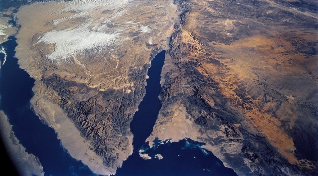
A lake simply does not fit these descriptions, nor does a marshy and shallow body of water in the Nile Delta. Indeed, this "Inland Sea" theory appears to be an attempt to create, in the words of Dr. Fritz, a "fording of the land" instead of a divine parting of the sea as written in Exodus (69). In this region, the Gulf of Aqaba is the most viable candidate, as the Gulf is a very deep body of water, more than 1000 meters deep in some places.
The Nile Delta "Reed Sea" theory rests on translation of Yam Suph as "Sea of Reeds," or "Papyrus Sea," as well as an understanding the region's climate. Glen Fritz notes that the climate at the Gulf of Suez is very dry and aid, with little sign of conditions that would favor a marshy area. This has inevitably led to the conclusion that this "Papyrus Sea," must be in the Nile Delta, the only location in this region that could contain such a body of water (137).
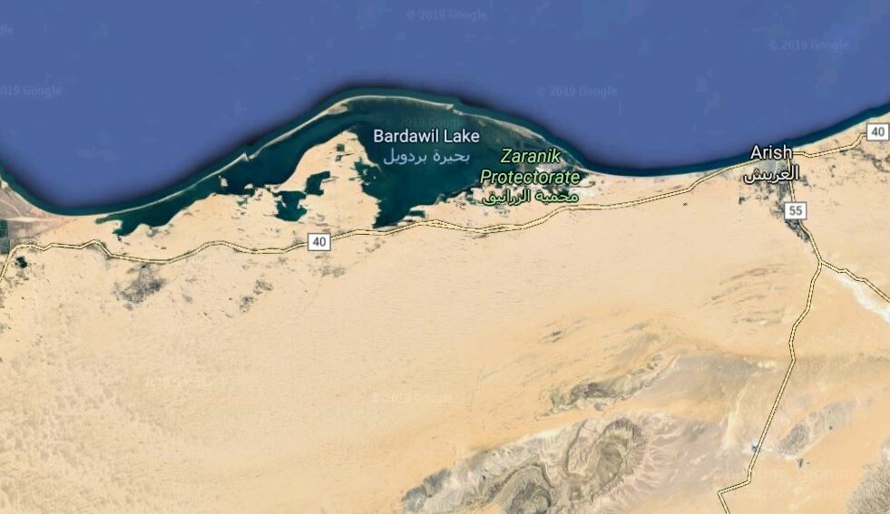
This Reed Sea theory arose during the 19th century, after a resurgence of Classical and Renaissance learning. The first scholar to separate Yam Suph from the Red Sea was Matthias Jakob Schleiden. He placed the Red Sea crossing at Lake Sirbonis (or Bardawil) along the Mediterranean coastline. He called this body of water, in German, "Schilfmeer," the same term Martin Luther used in his German translation of the Bible. In 1878, Egyptologist Heinrich Brugsch departed from the Red Sea tradition and also identified Yam Suph as Lake Sirbonis.
One major obstacle that Reed Sea proponents have to overcome is the fact that some of the lakes that we see on the map today did not exist in antiquity. Lakes Timsah and Menzaleh are bodies of water that came into being well after the date of the Exodus, Menzaleh specifically. As Glen Fritz carefully outlines in his book, the Nile Delta's gradual extension into the Mediterranean is what created this lake, and ancient ruins show that the delta's coastline was miles further south 3,500 years ago.
Some scholars have "pushed" the marshy region further south in an attempt to reconcile the Biblical account, which states that the Israelites did not travel by the Way of the Philistines (the northern route near the Mediterranean Sea). For example, Merrill Unger wrote in 1954 that the region near the Bitter Lakes and Lake Timsah was much more marshy 3,500 years ago. Glen Fritz notes that Unger's assertion substituted the papyrus translation for Suph and instead inserted the word "reed," which enabled the theory to "extend" to a region where papyrus cannot grow (138).
The Inland Sea was advocated by several prominent 18th and 19th-century scholars, including Andrew Crichton, Carl Ritter, and Lyman Coleman; included in this theory's proponents was Suez Canal Chief Engineer Edouard Naville.
The International Standard Bible of 1915, when discussing the Red Sea crossing, shows the naturalistic thinking behind the Inland Sea theory.
...There is at Suez, no extent of shoal water sufficient for the east wind mentioned in Scripture (Ex. 14:21) to have opened a passage-way sufficiently wide to have permitted the host to have crossed over in a single night...Besides, if the children of Israel were south of the Bitter Lakes, when there was no extension of the Gulf north of its present limits, there would have been no need of a miracle to open the water as there was abundant room for both them and Pharaoh's army to have gone around the northern end of the Gulf to reach the eastern shore, while south of the Suez, the water is too deep for the wind to have opened a passageway...
The naturalist explanation can logically lead to the conclusion that Yam Suph was a smaller inland lake because an event as described in the Bible would otherwise need an Act of God to have happened.
The Inland Sea theory is not the most valid explanation, though. Dr. Fritz notes that there are several Biblical passages that identify Yam Suph as the modern-day Gulf of Aqaba and not another body of water.
Yam Suph appears in the Hebrew Scriptures 24 times, with 11 of these verses having spatial/geographical content. Seven of these verses link Yam Suph with the historical lands of Edom or Canaan, which were directly north of the modern Gulf of Aqaba. This region is far removed from ancient Egypt.
Linguistic Analysis

Glen Fritz notes that there are 396 uses of the term Yam in the King James Bible. In a percentage of these uses, the most accurate translation is "west" or "Dead Sea" or "Tongue of Egypt." The context of these passages, especially those with the term Yam Suph, indicate that this particular body of water was a deep and great sea (98).
The various theories placing Yam Suph in the Nile Delta or Bitter Lakes appear to take a certain linguistic twist in his scholarly opinion. Since the time of the Septuagint, this sea was understood to be the Red Sea, Eruthra Thalassa, in Greek. However, Schleiden and Brugsch, mentioned above, made a botanical interpretation for the term, and they based their geographical understanding of Yam Suph in light of that, redefining it as an inland body of water and not a true sea (172).
Contemporary Egyptologists, like Dr. James Hoffmeier, adhere to the Reed Sea theory at least partially based on the theory that the Egyptian term "p3 twfy" or "pa-tjufy" are connected to Yam Suph, that pa-tjufy was in the northeast Nile Delta, therefore Yam Suph must also be in this location.
One potential problem is that if Yam Suph was a smaller body of water like a marshy lake, a more accurate term would have been agam, which translated means "pool, pond, swamp, or marsh," according to Strong's Concordance, 1990 edition. This word has a similar origin to the word agamon, which means "reed."
Strong's identifies 116 uses of the term Suph and related phrases like "soph," "supha," "saph," and "sapha." In entry 5488, it identifies four uses of the term that mean "flags, weeds, rushes, papyrus (?)." The entry curiously ends with a question mark.
Entry 5486 notes eight uses of the term where it translates to "to
cease, come to an end." Additionally, 5487 notes two uses that mean "to
be fulfilled, consumed, come to an end." The verb sapha can be translated as "consume, destroy, perish," according to entry 5595.
These disambiguations may exist because of the development of the Masoretic Hebrew text. As Greek and Aramaic gained popularity in the Jewish world, translators began introducing vowel marks, called pointing, into the existing text, which previously only had consonants.
Maurice Copisarow wrote that,
"...the introduction of complex grammatical forms, suffixes and prefixes, extra vowels and further differentiation by pointing, thus obscuring the origin, directness and simplicity of the patriarchal vocabulary...and hindered the analytical method of investigation"
M. Copisarow, The Ancient Egyptian, Greek, and Hebrew Concept of the Red Sea (Vetus Testamentum 12:1-13).
The development of Masoretic text could explain why there are so many variations of the word suph in the Hebrew language. However, just because there are a couple of variants that have an apparent vegetative meaning, this does not mean that all such occurrences refer to vegetation.
Professor Batto believes that the most plausible line of thinking is that suph refers not to vegetation, but to an ending of something.
...sup (or sop) must be derived from the Semitic root sup, 'to come to an end,' 'to cease (to exist).' As a substantive [as in, a noun] sup is attested in the meaning of 'end,' 'edge,' 'border' ...
B. F. Batto, “The Reed Sea: Resquiescat in Pace,” JBL 102 (1983), 34.
These translations point to a body water like the Gulf of Aqaba more than any other aforementioned ones. Given the fact that the Egyptian army was "consumed, destroyed, and perished" in Yam Suph, this name for the sea would make logical sense. Given the Gulf's ancient reputation as a treacherous sea to navigate, this also adds weight to the Aqaba location theory.
Glen Fritz further points out how the Exodus account offers several names for various bodies of water within the land of Egypt, such as the Nile, various streams, ponds, and pools. Not once is the word Yam used to describe these places (99).
In the Septuagint, the translators could have relied on a botanical understanding for the term Yam Suph, but they did not, instead opting for the Greek term for Red Sea, "Eruthra Thalassa." If the Septuagint scholars, the least far removed translators from the time of the Exodus, understood Yam Suph as a swampy and vegetated body of water, the question then becomes why they choose to use the Greek term Eruthra Thalassa.
Further adding to the linguistic difficulties is the fact that, as noted by Dr. Fritz, scholars have overlooked the fact that in the four places where the term "suph" refers to a reedy place, these places are also spots where the water ends (as stated above, suph could mean "to cease" or "to end"). He believes this constitutes reason enough for there to be a revision of interpretations for suph in these locations.
Geography
The writers of the Septuagint appear to rely on a Greek understanding of the geography. The translators, who lived in Alexandria, Egypt, translated Yam Suph into the Greek words Eruthra Thalassa, which translated means "Red Sea." Dr. Fritz notes that this move was more a geographical interpretation rather than a linguistic one (106).
Professor Batto further notes that the disconnect between the origin of the term Yam Suph and the name Red Sea is something that the Reed Sea proponents have yet to explain.
Thus, even if one were to grant the validity of the Reed Sea hypothesis, the etymology of yam sup = Red Sea would still be left unexplained. The burden of proof clearly falls upon those who would posit the existence of a second body of water farther north with the homophonous name of yam sup, in addition to the well-known yam sup = Red Sea.
B. F. Batto, “The Reed Sea: Resquiescat in Pace,” JBL 102 (1983): 28.
A linguistic understanding based on a botanical interpretation may lead one to identify Yam Suph as a marshy lake. However, a geographical angle first, which then informs the linguistic understanding, may actually offer a more solid theory for the Red Sea crossing location. We contend that both the linguistic and geographical understandings must inform and complement each other to arrive at an accurate conclusion.
Biblical Evidence
The Bible has a number of passages that use the term Yam Suph to describe a specific body of water. These passages largely follow the Septuagint's translation, using the term Red Sea. With the traditional term "Red Sea" being replaced with the more accurate Yam Suph, each passage indicates that Yam Suph was closer to the Edomites and Canaanites than the Egyptians.
1 Kings 9:26 - King Solomon also built ships at Ezion Geber, which is near Elath in Edom, on the shore of [Yam Suph].
Exodus 23:31 - “I will establish your borders from [Yam Suph] to the Mediterranean Sea, and from the desert to the Euphrates River. I will give into your hands the people who live in the land, and you will drive them out before you."
Jeremiah 49:21 - At the sound of their fall the earth will tremble; their cry will resound to [Yam Suph].
Numbers 14: 25 - "Since the Amalekites and the Canaanites are living in the valleys, turn back tomorrow and set out toward the desert along the route to [Yam Suph]."
Numbers 21:4 - They traveled from Mount Hor along the route to [Yam Suph], to go around Edom.
Deuteronomy 1:40 - But as for you, turn around and set out toward the desert along the route to [Yam Suph].
Deuteronomy 2:1 - Then we turned back and set out toward the wilderness along the route to [Yam Suph], as the Lord had directed me. For a long time we made our way around the hill country of Seir.
Deuteronomy 1:1 also points to the Red Sea of the Exodus as the Gulf of Aqaba. Multiple translations of this passage, including the NASB, NIV, ESV, and NLT, leave the word Suph in its original form and do not read "Red Sea" or "Sea of Reeds."
These are the words that Moses spoke to all Israel beyond the Jordan in the wilderness, in the Arabah opposite Suph, between Paran and Tophel, Laban, Hazeroth, and Dizahab.
The Arabah Valley is to the north and northwest of the Gulf of Aqaba. Deuteronomy 1:1 would not likely have been referring to Suph as a sea close to or within the land of Egypt when using the Arabah as a proximity point.
None of the above verses indicate an Egyptian connection in any way. The references to Yam Suph in these passages show close proximity to Edom and Canaan, but not Egypt, which would be approximately 150 miles to the west, according to Dr. Fritz.
Several of the above verses, including 1 Kings 9 and Numbers 21 specifically name Edom as a point of proximity when referring to Yam Suph. The land of Edom encompassed the territory north of the Gulf of Aqaba, approximately up to the Dead Sea. If the Red Sea crossing took place further west, at the Gulf of Suez, Bitter Lakes, or Nile Delta, the author would certainly not have referred to Edom as its territory did not extend into Egypt.
The references to Mount Seir also indicate that Yam Suph was the Gulf of Aqaba. As Dr. Fritz notes, Seir and Edom were synonyms for the same region, which was inhabited by the descendants of Esau (Deuteronomy 2:8).
Mid-20th-century archaeologist Nelson Glueck had the following to say regarding the location of Edom and Seir, and their relation to each other:
There is confusion in the Bible with regard to the relationship of Seir and Edom. They are equated with each other, and are located variously both on the east and west sides of the Aravah. The solution, I believe, lies in remembering that when Edom was conquered by the Babylonians in the sixth century B.C., large numbers of the Edomites were pushed out of their country by the Nabataeans. They crossed the wadi Aravah and settled in southernmost Palestine...Generally speaking, Edom is mentioned in the Bible with anger and bitterness (1 Kings 11:14-22; Isaiah 34; Jeremiah 49:17-22; Ezekiel 24:12-14; Amos 1:1), and is considered as being on the east side of the Wadi Aravah.
Nelson Glueck, Rivers in the Desert (Farrar, Strauss & Cuhady, New York: 1959), 153-154.
Part of the confusion, in Dr. Fritz's estimation, is due to a translation error. Yam Suph was taken to mean "Sea of Reeds" by many scholars, but there are very few times when the word "suph" refers to anything having to do with vegetation. Out of 116 total uses of the word, only four of them can arguably be connected to the word for reeds or plant (164).
This theory is reinforced by the fact that King Solomon built his fleet at Ezion-Geber upon the waters of Yam Suph in 1 Kings. Why would a fleet be built on a marshy swamp or on a landlocked lake (especially water that would have been under Egyptian control)? It makes much more sense that the fleet Solomon constructed was at the Red Sea's Gulf of Aqaba.
Church historian and scholar Arthur P. Stanley, writing in 1865, also confirmed his knowledge of the Gulf of Aqaba (or Eilat), noting that King Solomon set his ships on this body of water.
...The Gulf of Eilat...up and down which the fleets of Solomon brought the gold of Ophir...now there is not a single boat upon it from end to end. Once a year and only once, boats come around from Suez to Akaba with provisions for the Mecca pilgrims; and all other times it is desolate as the wilderness...
Arthur P. Stanley, Sinai and Palestine in Connection with their History (W.J. Widdleton, New York: 1865), 82.
Further cementing this historical fact, Professor Colin Humphreys of the University of Cambridge, author of The Miracles of Exodus: A Scientist's Discovery of the Extraordinary Natural Causes of the Biblical Stories, writes:
Presumably the wise Solomon would not have built his ships on an inland reedy lake, since he would not have been able to get them out! The precise locations of ancient Elath and Ezion Geber are uncertain, although many scholars believe that Elath was in, or close to, modern Aqaba in Jordan, on the northeast side of the head of the Gulf of Aqaba. However, we do know that ancient Edom was a country adjacent to the Gulf of Aqaba, hence we can say with reasonable certainty that the biblical yam suph is the Gulf of Aqaba, which is one arm of the Red Sea (the other arm being the Gulf of Suez). Yam suph may refer to other bodies of water as well, but I suggest that it is beyond reasonable doubt that the biblical yam suph includes the Gulf of Aqaba.
Professor Humphreys also mentions that the translators of the Septuagint, the Greek translation of the Old Testament, identified the Hebrew Yam Suph as the Eyrthraean (Red) Sea. The translators deliberately did not translate the Hebrew phrase into the words "Sea of Reeds," and some deference ought to be given to these translators, who were in Alexandria, Egypt at this time.
What seems to make more sense than the is that Yam Suph is the Gulf of Aqaba, not a marshy lake or otherwise landlocked body of water, and that Solomon built his fleet on that body of water, the same sea that the Israelites crossed several hundred years earlier.
Part of the difficulty, as we mention on our maps page, is that the ancients did not fully grasp the Gulf of Aqaba in their understanding of the region's geography. The Gulf of Aqaba is much more treacherous to travel upon than the Gulf of Suez, which, in Dr. Fritz's opinion, delayed its exploration and understanding for many centuries. This misunderstanding need not necessarily cause us to misunderstand the geography, though, even with many centuries having past since the Exodus.
Ancient map writers and historians such as Pliny the Elder, Ptolemy, Strabo, Agatharchides, and Eratosthenes did not have the tools necessary to fully understand the Red Sea's true geography. In one of Ptolemy's maps of the Red Sea, he severely miscalculated the longitude and outlined a small peninsula-like structure at the north end of the sea, but it nowhere near an accurate representation of the sea's true appearance.
Dr. Fritz notes that during the resurgence of knowledge in the Renaissance, the Classical era's understanding of the geography was entrenched by the proliferation of new maps, and this faulty understanding continued on into the 19th-century. This misunderstanding took its place as largely unquestioned truth because there were few other available options in that time. However, modern analysis of the Red Sea and Sinai Peninsula offers more clear answers for the true location of Mount Sinai if long-held assumptions are examined more carefully.
The Red Sea makes sense as the body of water the Israelites crossed because of the Biblical text's indication that it is a particularly massive geographic feature. The ancient misunderstanding of the region doesn't preclude the Gulf of Aqaba from being the crossing point. Pastor Mario Seiglie writes that there is no way that Yam Suph was a marshy lake or even a large lake. Rather, only the Red Sea itself fits what the text implies.
Notice also Numbers 33, which mentions the stops the Israelites made in the wilderness of the Sinai. After crossing “the sea,” they camped in Marah, then Elim. And “they moved from Elim and camped by the Red Sea [yam suph]” (verse 10). How could they have crossed a “sea of reeds” and, after many days of travel, still camped by that same “sea of reeds”? No body of water in the region except the Red Sea would have been enough for the Israelites to have traveled so long and still be close to its coast.
Other descriptions of this route include that it was "off the main road", a "rough and untrodden wilderness," and a "pathless track." This was not an established route by which anyone traveled, by any means, according to these accounts. This body of water where the Red Sea cross took place was simply not in an established location but in a true wilderness setting.
The only notable mention of a body of water closer to ancient Egypt is in Isaiah 11, with the Gulf of Suez being referred to as "the tongue of the Egyptian Sea" according to the prophet. A Bitter Lake explanation doesn't hold up to closer scrutiny that goes beyond simply accepting the traditional theory as fact.
Dr. Fritz states that the "botanical interpretations" for Yam Suph are the result of "innocent embellishment of the biblical scenarios." The issue is that these embellishments have led to problematic interpretations for the true location of the Red Sea crossing.
Another issue with the Reed Sea claim is that there is little historical evidence indicating that there was a large quantity of fresh water resources in the isthmus of Suez during antiquity. However, as Dr. Fritz notes in The Lost Sea of the Exodus, this point has largely been overlooked (82).
Explaining Yam Suph Away
With the evidence for Yam Suph being the Gulf of Aqaba, many researchers have attempted to work around this by developing broader explanations. Some of these explanations include applying Yam Suph to the entirety of the Red Sea, and not just the Gulf of Aqaba; Yam Suph meaning multiple locations; excluding Yam Suph from the Sea of the Exodus; and completely ignoring it, or dismissing it as mythology.
Sir Hanbury Brown wrote in 1919 that there is no evidence that the Gulf of Suez was not also called Yam Suph. However, as Dr. Fritz notes, this is a fallacy of negative proof, and the burden of proof is shifted onto the respondent rather than the claimant (102).
Nahum Sarna wrote in 1996 that Yam Suph referred to the entire collection of lakes, marshes, and the gulfs of the Red Sea. Since this encompasses a large area and a number of different bodies of water, this only serves to add to the confusion regarding Yam Suph's real identification and location.
Others have claimed that Yam Suph was an entirely separate body of water from the sea which the Israelites crossed in Exodus 14. A.H. Sayce wrote in The "Higher Criticism" and the Verdict of the Monuments in 1894 that "The 'sea' which was crossed by the Israelites according to the narrative of the Exodus (apart from Miriam's song), was not the Yam Suph, but a sea which adjoined the Egyptian frontier." Dr. Fritz again notes that such an explanation adds unnecessary confusion and complexity to the Exodus narrative, which the Biblical text and geography do not require.
Going one step further, some researchers have dismissed Yam Suph as a mythological location, with Egyptologist Donald Redford claiming that the parting of the waters and drowning of enemies are known in Egyptian folklore. Redford did admit, however, that the Exodus account is written more as a history than as a mythology.
Regarding myth formation in the ancient Near East, Egyptologist Kenneth Kitchen wrote,
The ancient Near East did not historicize myth (i.e., read it as imaginary 'history). In fact, exactly the reverse is true--there was, rather, a trend to 'mythologize' history, to celebrate actual historical events and people in mythological terms.
Kenneth A. Kitchen, On the Reliability of the Old Testament (William B. Eerdmans Publishing, Grand Rapids, MI: 2003), 262.
Many of these assertions rest upon assumptions that Mount Sinai must be in Egypt at St. Catherine's, or that it did not happen at all.
Where Did the Red Sea Get Its Name?
Dr. Colin Humphreys further writes in The Miracles of Exodus that the sea's name has often been a conundrum for many scholars over the years, himself included. The fact that the Greek Septuagint scholars translated Yam Suph as "Red Sea" is a mystery. However, on one trip to the Gulf of Aqaba, he noticed something very peculiar when looking over the Gulf from a hotel room: large red spots in the water.
He went down to the shore to investigate, and found a rather interesting phenomenon that could explain the Red Sea's nominal origins:
I was sitting in our bedroom on the sixth floor of our hotel in Taba and had just finished reading this passage [from Dr. Jim Hoffmeier's book "Israel in Egypt"]. My wife was lying on the beach below, reading a book. I stood up to go and join her and glanced out of our hotel room window. The normally deep blue Red Sea was covered with large red patches of color, as if someone had sprayed red paint on it. The effect was very clear and striking and could be seen some distance away...
I rushed excitedly from the room, ran down six flights of stairs, not waiting for the elevator, and strode rapidly out of the hotel, past the swimming pool, and on to the pebbly shore. The large red blotches of color on the water of the Gulf of Aqaba were still there!
Colin Humphreys, The Miracles of Exodus: A Scientist's Discovery of the Extraordinary Natural Causes of the Biblical Stories, (New York: HarperCollins, 2003), 183-184.
Dr. Humphreys observed the low tide revealing the red coral that lay just below the water's surface. It was the coral that made the water appear red, which could be why the Red Sea came to be called such. After about thirty minutes, the tide came back in and covered the coral, which caused the water to return to its normal deep blue color.
Dr. Humphreys also noted that there is another phenomenon that could lead to the name "Red Sea." The mountains which border the Gulf of Aqaba in Saudi Arabia and Jordan are reddish in color, and at certain times, especially around sunset, the sun's light reflects off the mountains and water to give the sea reddish color as well.
The Red Sea's name has been a stumbling block for centuries, but Dr. Humphreys makes some strong arguments that the Red Sea is Yam Suph, and that the debate over the sea's name does not demand a marshy inland or Bitter Lakes crossing.
A Sea of Reeds After All?
Professor Humphreys writes that the Gulf of Aqaba is a unique body of water. The Red Sea is a saline body of water, and reeds tend to not grow in salty water. However, there is a strange phenomenon at the northern part of the Gulf, as observed by one explorer in the early 20th century.
The Czech explorer Alois Musil, in "The Northern Hegaz," written in 1926, describes an extremely unusual feature of the northern seashore at the head of the Gulf of Aqaba: it contains fresh water. He writes: “At low tide the rocky shore was laid bare for a distance of about two hundred yards, uncovering numerous springs which gushed forth with great strength.” Musil then emphasizes the excellent quality of this fresh water: “The animals [camels] did not wish to drink from the fresh water from the well, preferring to go to the sea shore where they very readily drank from the many springs which flowed there.”
What is the origin of the water in these freshwater springs at the head of the Gulf of Aqaba? It comes from rain water falling on the mountains bordering the Arabah. The water is then funneled along and under the sand of the Arabah down towards the Gulf of Aqaba, where it breaks out on the seashore as freshwater springs.
If reeds grow in the body of water we know as the Red Sea, the contention that Yam Suph is actually a Sea of Reeds, and it literally refers to a sea that had reeds in the water, Humphreys' assertion could make the pieces fit together coherently.
Indeed, in his travels to this part of the world, Humphreys claimed to have found reeds at the extreme northern end of the Gulf. While walking through the remains of the ancient Roman port city of Aila, he and his wife explored the remains that had been uncovered, including a wadi that ran through the city in ancient days. This wadi runs from the Arabah, through Aila, and down to the Gulf.
Humphreys then reportedly found an unexpected sight in the wadi.
And then I saw them. Reeds! Great clumps of tall reeds, fourt to six feet high on the far bank of the wadi running through the archaeological site of Aila. I couldn't believe what I was seeing! I had been thinking about reeds (in fact, I had been thinking about the absence of reeds) many times since our arrival in Egypt three days before, and here they were! How very curious.
Colin Humphreys, The Miracles of Exodus, 189-90.
The reeds were about 200 yards from where the Gulf's waters started. But since Aila was a harbor city, the waters must have extended up to the city's limits two thousand years ago. What happened since? Humphreys hypothesizes that since the Gulf is a part of the Great Rift Valley, and the land in this part of the world is gradually sinking, that the waters must have receded since the time of the Roman Empire.
He then traveled to Eilat in Israel at the northwestern edge of the Gulf, in an area that had yet to be developed, and found more reeds near the water's edge. While exploring the Wadi Shlomo (Shlomo is the original Hebrew for Solomon) between Taba and Eilat, he found another patch of reeds near the Gulf's waters.
In ancient times, there may have been even more reeds at the head of the Gulf, but modern building development, as well as topographical changes, may have reduced the prominence of reeds in this region. However, before these changes, it is entirely possible that the northern end of the Gulf had many reeds and that ancient peoples recognize this and offered the name Sea of Reeds to demarcate this unique body of water.
One ancient source, Greek historian and geographer Agatharchides, claimed that there was a large amount of vegetation under the waters of the Red Sea. He wrote that there was "...abundant seaweed and vegetation [that] is visible under the water." Pliny the Elder also noticed this as well, stating that "there are whole forests found growing...The size of shrubs is three cubits in height..."
In contrast with the Gulf of Aqaba, the Gulf of Suez does not have any record of reeds in its waters. Thaddeus Mason Harris, a Harvard librarian and Unitarian minister, wrote about the noticeable lack of vegetation in the Gulf of Suez.
I nowhere observed any species of the flag kind; we have little reason, therefore, to imagine that this sea should receive a name from a production which does not properly belong to it.
Thaddeus Mason Harris, A Dictionary of the Natural History of the Bible (T.T. & J. Tegg, London: 1833), 115.
This was confirmed by 19th-century French explorer Leon Laborde when he traveled to the Gulf of Suez.
As far back as records reach, we find this sea called, by Moses Jam Suph, the Sea of Rushes. This appellation is hardly justified by the few rushes which are found near some springs on the western coast.
Leon Laborde, Journey Through Arabia Petraea, to Mount Sinai. and the Excavated City of Petra, the Edom of the Prophecies (John Murray, London: 1836), 264.
One additional piece of input to consider comes from a former British colonial governor of the Sinai Peninsula, C.S. Jarvis. Governor Jarvis extensively studied the Sinai during his tenure, including how it relates to the Exodus.
He favored Lake Sirbonis as Yam Suph, but he also made a most interesting observation about the Sinai Peninsula next to the Gulf of Aqaba.
In his 1931 book Yesterday and to-day in Sinai, he wrote:
It is interesting to note that the Mohammedans believe that the disaster occurred on the opposite side of Sinai in the Gulf of Akaba, though what the Egyptian army were doing there remains a mystery.
Claude Scudamore Jarvis, Yesterday and to-day in Sinai (Edinburgh/London: W. Blackwood & Sons, 1931), 162-163.
There's nothing in the historical record that indicates the Gulf of Suez was the "Reed Sea," but the Gulf of Aqaba does have such evidence. We further explain on another page why the Gulf of Suez was most likely not where the Israelites crossed the Red Sea.
Conclusion
With this information in mind, the question (again) becomes where exactly the crossing took place. Just over the past two centuries, a large number of new Red Sea location theories have proliferated and only added to the confusion. It is understandable why some scholars have claimed that Yam Suph means "Sea of Reeds," but a closer look at the Biblical text, geography, and language shows that this interpretation is not likely the correct one.
However, there is a wealth of information available to clear up the uncertainty, and the most plausible body of water for the Red Sea crossing, in our assessment, is the Gulf of Aqaba.
On our Red Sea Crossing candidates page, we detail two of the most likely locations.
Last updated July 23, 2019.