Maps of Mount Sinai, Egypt, and Midian

The following maps and images of the Mount Sinai site help show where each component is located. These maps show parts of northwestern Saudi Arabia, with the Red Sea's Gulf of Aqaba to the west. Below maps of the mountain's location are additional maps detailing the boundaries of Midian and Egypt.
The image below shows how the sites allegedly matching the Exodus story are clustered together. Jabal Maqla, the favored candidate for Mount Sinai/Horeb, is the mountain with a black top.
To the northwest of Jabal Maqla, there is a marker locating the distinctive split rock that may be the "Rock of Horeb" in/near the Rephidim encampment (which is where the Israelites fought the Amalekites).
To the northeast of Jabal Maqla, one can see where an ancient, pre-Islamic burial site is located. It is away from the Holy Precinct near the mountain and outside of the plain where the Israelites would have camped. It is also off the path that the Israelites would travel through. Its placement makes it a match for the burial ground for the worshipers of the Golden Calf.
Directly to the east of the mountain, you can see where the possible Altar of Moses is located, at the foot of the mountain. The possible Cave of Elijah is almost directly above it. Further to the east (behind the Altar of Moses) is the archaeological site that may have been where the worship of the Golden Calf took place.


Egypt and Midian
One important point in discovering the true location of Mount Sinai is to identify boundaries between ancient empires and lands. The Bible states in no uncertain terms that Moses went out of Egypt into Midian, so he could not have been within lands controlled by the ancient Egyptian empire.
Below are several maps of the region that show where ancient Egypt and Midian were located.

In the above map, the Sinai Peninsula is included as a part of ancient Egypt. St. Catherine's mountain, the traditional location, is located in the southern part of this peninsula. If Moses brought the Israelites out of Egypt, he would not have stopped in territory that was under Egyptian control.
In the 16th century B.C., Pharaoh Ahmose took control of the Sinai Peninsula in his fight against the Hyksos.
The king immediately prosecuted the Hyksos' Palestinian associates by besieging Sharuhen, eventually plundering its wealth and massacring its population. In doing so Ahmose brought under his unquestioned control the roads across Sinai, and also reasserted the sort of boundary between Egypt and Palestine that had existed during the Middle Kingdom, before its erosion by the independent kingdom of Avaris.
Bill Manley, The Penguin Historical Atlas of Ancient Egypt (London, England: Penguin, 1996), 66.
Dr. Allen Kerkeslager, in his scholarly study of Jewish Pilgrimages, also noted that during the Late Bronze Age, the Egyptians did control the Peninsula, and would have had troops to guard their interests.
The entire Sinai Peninsula at least as far east as the Avrah was withing Egyptian territory in the Late Bronze Age. Egyptian interests were guarded by Egyptian troops, especially in the southwestern Sinai peninsula, as testified by reliefs and the sheer importance of the turquoise and copper mines of the region ...
The southern Sinai peninsula was quite simply not in Midianite territory. The boundaries of Midianite territory were just slightly southwest of modern Eilat on the extreme northwestern shore of the Gulf of Aqaba.
Allen Kerkeslager, “Jewish Pilgrimage and Jewish Identity in Hellenistic and Early Roman Egypt,” in Pilgrimage and Holy Space in Late Antique Egypt, ed. David Frankfurter (Leiden: Koninklijke Brill, 1998), 151 (footnote 215).
In The Miracles of the Exodus: A Scientist's Discovery of the Extraordinary Natural Causes of the Biblical Stories, Dr. Colin Humphreys also notes that the Egyptians controlled this territory and were very much active mining copper and turquoise at Serabit el-Khadim (48).
Humphreys' research led him to conclude that the ancient Egyptian Empire began to lose control of the peninsula after the reign of Ramses II, sometime around 1194 - 1163 B.C. At either proposed date for the Exodus (1250 B.C. or 1446 B.C.), the peninsula would have been patently Egyptian-controlled territory.
Czech explorer and Professor of the Orient Alois Musil also wrote that the Sinai Peninsula was controlled by the Egyptians during the time of the Exodus, making the traditional location out of the question.
If any great tribe flees today from the government and the army of a civilized state, it proceeds rapidly along the most convenient and most direct transport route, if only to escape as soon as possible from the territory and jurisdiction of the military power. Such also was the case in the fifteenth century before Christ, when the Israelites migrated from Egypt. The peninsula of Sinai at that time contained Egyptian garrisons. The tribes living there were more or less dependent upon Egypt and would have received orders to attack the Israelites with their garrisons and thus force them to return. The Israelites were therefore obliged to hasten so as to traverse the peninsula of Sinai before the garrisons were strengthened and the nomads incited against them.
Alois Musil, The Northern Hegaz: A Topographical Index, American Geographical Society (1926), 267.
Given this historical fact, it would not make sense for the Hebrews to flee to the Sinai Peninsula away from the Egyptians when the Egyptians controlled this very territory and had troops garrisoned in the region.
Indeed, the Scripture indicates dozens of times that the people went out of Egypt, and into another land (Exodus 3:8, 10-12; 6:11, 13, 26; 7:5; 12:17, 39, 42; 13:8-9, 14, 16, 18, among a host of other passages throughout the Pentateuch, Old Testament, and New Testament).
With these pieces of information in mind, it becomes nearly impossible to then justify the traditional site for Mount Sinai. The Israelites simply must have crossed into Midian at the Red Sea, and not into another portion of existing territory.
On the other side of the Gulf of Aqaba (or Yam Suph in ancient Hebrew) is Midian. The two most plausible theories for how the Israelites crossed into Midian are the Straits of Tiran and Nuewiba Beach options.
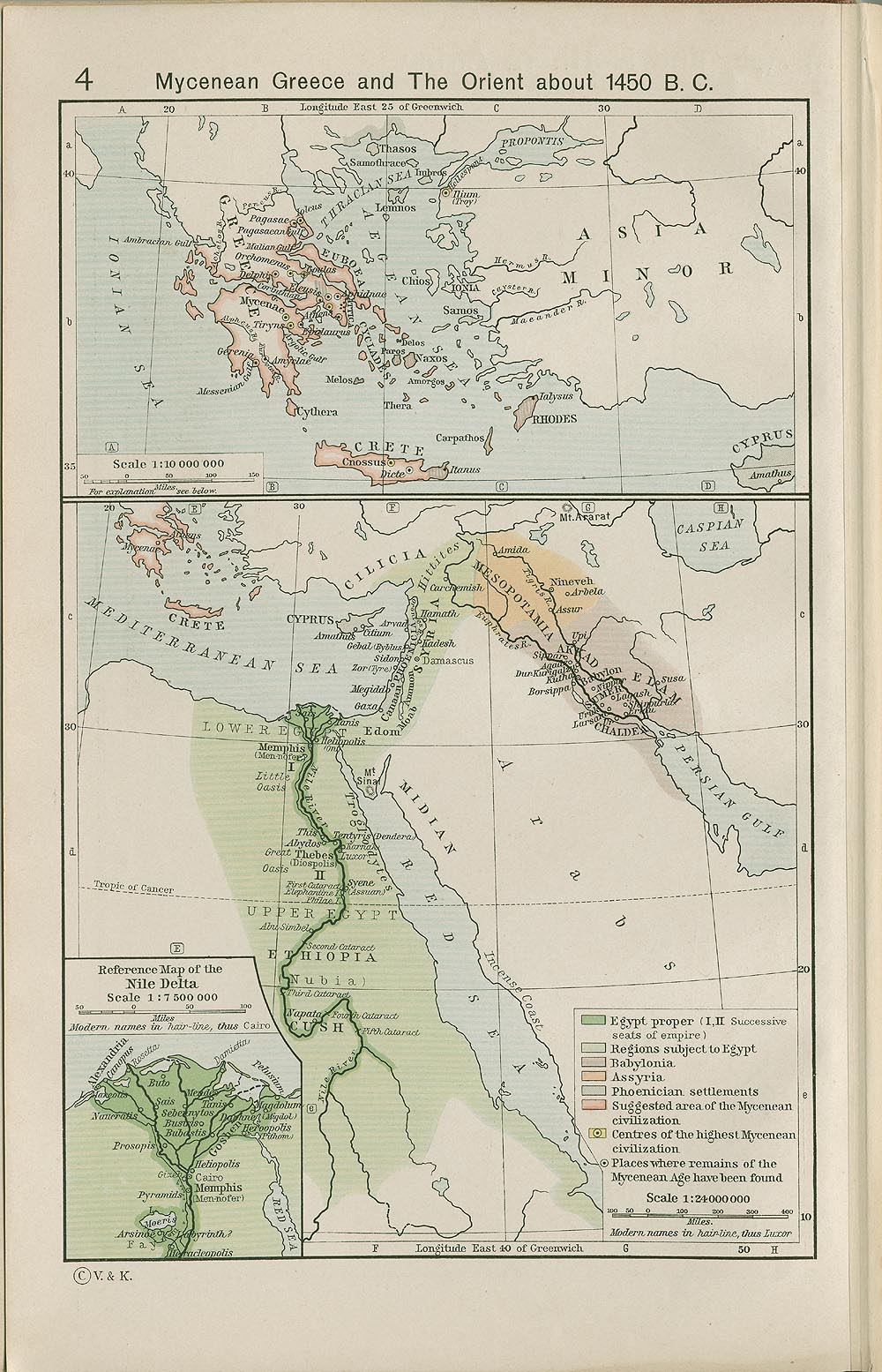
In this map below, "Mycenean Greece and The Orient," drawn by William R. Shepherd in 1911, he shows that the ancient Egyptian realm in 1450 B.C. encompassed the Sinai Peninsula, and Midian was on the east side of the Gulf of Aqaba. He included Mt. Sinai on the Peninsula in this map, so it is uncertain if he considered the territorial problem with this theorized location.

In spite of the historical fact that the Sinai Peninsula was technically under Egyptian control at this time, some historians and archaeologists still insist on the traditional location. The line of reasoning is frequently similar among these proponents, as Joel Richardson explains in his book Mount Sinai in Arabia: The True Location Revealed.
First, they claim that the common understanding of the term “Arabia” in Paul’s day would have included the Sinai Peninsula. We agree with this. From there, however, without any basis to do so, they simply say that this is where Paul must have been referring.
Richardson, 89.
One example of this is Dr. James Hoffmeier's assertion that the term "Arabia" included the Egyptian Sinai Peninsula in Greco-Roman times. However, Hoffmeier asserts that because this region was included, when Paul referred to Arabia in Galatians 4:25, he was referring specifically to the Peninsula and nowhere else.
One Egyptologist, David Rohl, states plainly that the assertion Paul was referring to anywhere but the Peninsula is "complete nonsense" in his book Exodus: Myth or History?
Gordon Franz, advocate for Jebel Sin Bishar in the Western Sinai Peninsula, has the following to say about the map identification of Arabia.
The Galatians 4:25 reference might indeed support the view that Mount Sinai was in Saudi Arabia if the Apostle Paul was looking at a 1990 Rand McNally Atlas. However, it would not be true if he was looking at a First Century AD Roman road map.
Gordon Franz, “Is Mt. Sinai in Saudi Arabia?” Bible and Spade, Fall 2000.
The problem with Franz's objection is that Greco-Roman maps did not identify the land that is now Saudi Arabia as such, and obviously so. Though the names of these regions have changed over time, the landscape itself has not.
In Paul's day, the term "Arabia" may have been used in a variety of ways, but it certainly wasn't limited solely to the Sinai Peninsula, a region that many ancient cartographers did not fully understand, as many old maps do not show both the Gulfs of Suez and Aqaba, including several of the ones towards the bottom of this page.
The following map from 17th Century English cartographer John Speed shows the Red Sea as almost one continuous body of water, rather than one that splits into the two gulfs, forming the Sinai Peninsula. The Peninsula can roughly be seen from his drawing, but the gulfs hardly exist according to maps from several centuries ago.

In spite of the fact that ancient cartographers misunderstood the Gulf of Aqaba, this doesn't detract from the validity of the theory that Mount Sinai is in Saudi Arabia. As Joel Richardson writes in his book:
Even among the Greco- Roman geographers, unqualified references to Arabia would most likely point to the Arabian Peninsula. In the fifth century BC, the Greek historian Herodotus used the term “Arabia” to identify the Arabian Peninsula. In fairness, however, as we have discussed elsewhere, even though Herodotus was not aware that the Sinai Peninsula even existed, he still would have viewed it to be part of Arabia.
...
Consider a simple analogy. Imagine that I said, “God Bless America.” No one living today would understand me to be referring to Canada, Costa Rica, or Brazil. Technically however, these are all parts of North, Central, or South America.
Richardson, 92.
It is true that the region of Arabia, as the Greco-Romans understood it, could certainly have included the Sinai Peninsula, but it's not likely that Arabia was the exclusive name for the Peninsula.
Historical Maps of Arabia Identifying Mount Sinai/Horeb
Several maps from centuries past have identified Mount Sinai/Horeb as being in what is likely Saudi Arabia. The ancient cartographers, who lacked our modern technology, tended to omit the Gulf of Aqaba from their maps of the region because they could not identify it in relation to the rest of the land and sea.
In spite of this lack of knowledge, the cartographers did appear to place Mount Sinai and Midian far enough east to be located not in the Sinai Peninsula, but the Arabian Peninsula. If anything, based on a more careful examination of the evidence, it leads us to believe with more surety that Mount Sinai is not at St. Catherine's in Egypt, but is across the Gulf of Aqaba in modern-day Saudi Arabia.
Dr. Glen Fritz notes in his book The Lost Sea of the Exodus that because of this geographical misunderstanding, this led scholars and theologians to simply accept the proposition that Mount Sinai was in Egypt's Peninsula with little contention (67). It wasn't until the 16th-century that any real understanding of the Gulf's size, and it was only the mid-1800s when maps began to reflect the Gulf's true significance.
There are two maps that have specifically placed Mount Sinai, Horeb, and Midian in these locations. The first is from 1654, a map of Arabia drawn by Chez Pierre Mariette. In the northwestern part of the map, one can see clearly marked "Sinai Mont" and "Mont Oreb."
To the southeast of Mont Oreb, there is also a city labeled as "Madian." This alternate spelling of Midian indicates that Sinai/Oreb (Horeb) in the surrounding area, and because Midian was mostly or entirely in modern day Saudi Arabia, is can be inferred that Mount Sinai may not have been in the Sinai Peninsula as the traditional theory maintains.

About three decades later in 1682, Dutch cartographer Frederick de Wit also drew a map of the Arabian Peninsula and identified Madian, Horeb M., and Sinai M. on his map.

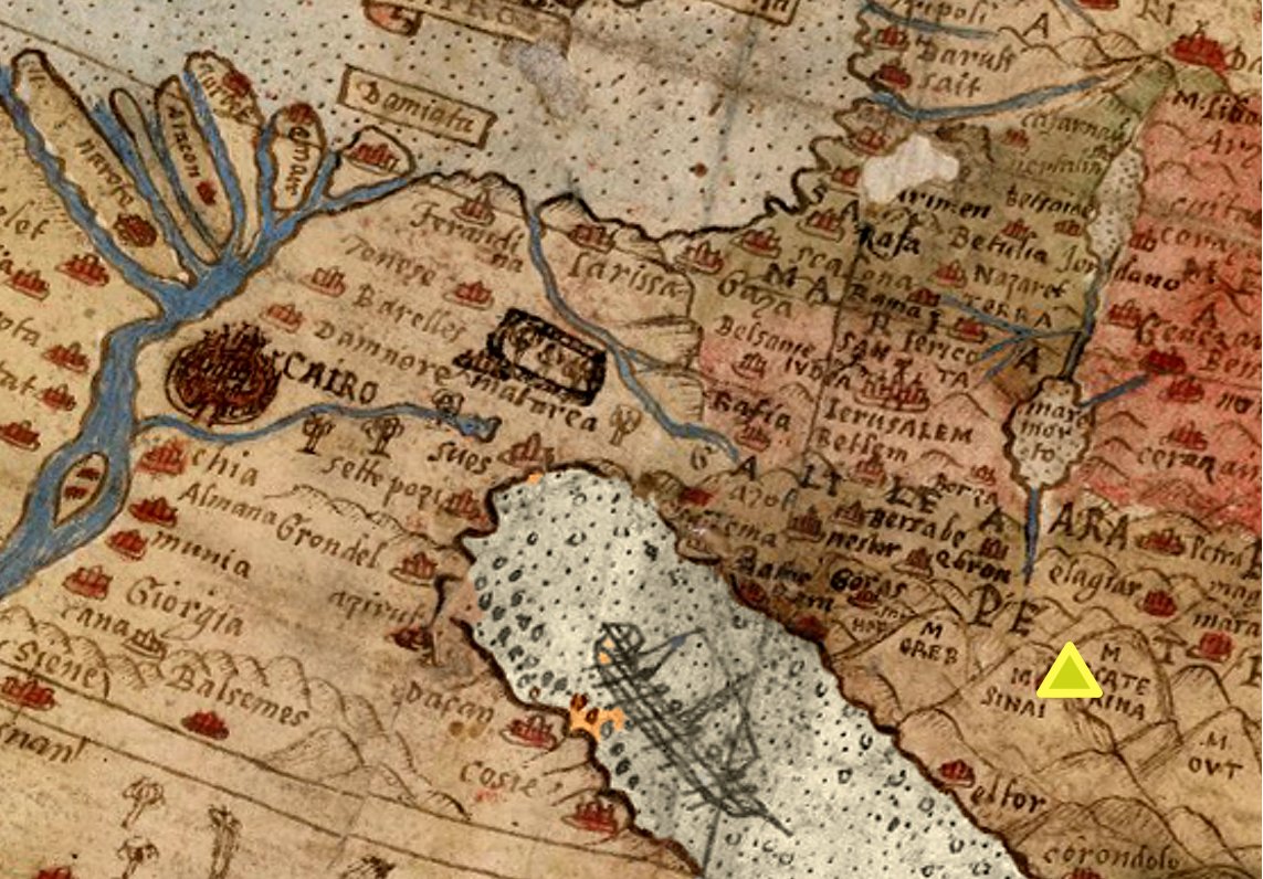
Another Middle East map listing Mount Sinai is from Urbano Monte in 1587. This map, like the ones shown above, do not show the Gulf of Aqaba in its portrayal of the region. Sinai is marked by a yellow triangle on the right side.
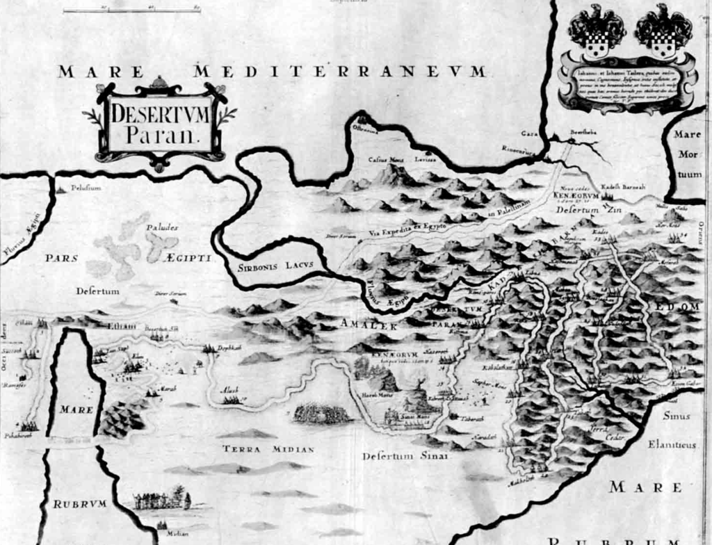
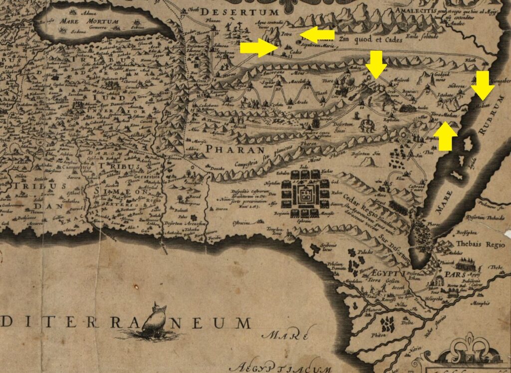
17th-century cartographer Thomas Fuller also appears to have placed Mount Sinai in modern-day Saudi Arabia. On the map, he marked the "Desertum Sinai," "Sinai Mont," and "Horeb Mont" to the east of "Terra Midian."
Since Midian is known to be in modern Saudi territory, and Fuller placed Mount Sinai to the east, one may reasonably see that he understood that Mount Sinai was in the land of Midian.
As with previous maps, the Red Seas two gulfs are not properly shown here.
Another map drawn by Joannes Joansonius around 1650 A.D. indicates that Moses and the Israelites traveled to the land of Midian in their journey from Egypt, and also that Kadesh-Barnea was not within the borders of the Promised Land, but rather was at what we now know to be Petra, Jordan.
Just as with other pre-19th century maps, the Gulf of Aqaba is not on this map. What Joansonius does show on here, though, is that Mount Sinai was to the east of the city of Midian, which lay near the coast of the Red Sea.
This map is oriented "upside down," with the south being toward the top of the map, and the north at the bottom, so it may be difficult to orient all the points. Because of this unusual orientation, the left side of the map represents the east direction, and the right side represents the west.
We've noted where locations of interest are, including Sinai Mont and Oreb Mont (middle arrow pointing down) Madian (on the right pointing down), Terra Madian (on the right pointing up), Cadesh (on the left pointing right), and Petra (on the left pointing left).
Page last updated July 2, 2019.
On the web page http://lpt.ffb.myftpupload.com/maps-journey-sites-sinai/ you said:
To the northwest of Maqla, there is a marker locating the distinctive split rock that may be the “Rock of Horeb” in/near the Rephidim encampment (which is where the Israelites fought the Hebrews).
I think you meant too say that the Israelites fought the Amalekites. (Ex 17)
Also, please pass along to the experts that the possible route was initially directly from Goshen to somewhere near what is now Gaza. This is the probable reason why Pharaoh did not pursue them as the effort would have been wasted since the Israelites could enter Canaan before his army could reach them. They abruptly turned South to the location indicated by Mr. Fritz and is the reason why they were then pursued. (Ex 14:3) This, however, is just conjecture on my part. Nevertheless, please consider it among the possibilities. Excellent website. Absolutely excellent.
Thank you! Yes, we will fix that. Thank you for your thoughts on the circumstances surrounding the Exodus story. It is fascinating to review all of these details to understand their contexts. The well-known trade route from Egypt to Midian would not have led the Israelites into Gaza (the land of the Phillistines) as it was just south of that area.
Question: are we analyzing the crossing using current data, but not taking into consideration the landscape from 3500 years ago?
For example, the width of the Red Sea is quite wide, but I wonder if 3500 years ago it may have been more narrow giving plausible rise to the notion that a strong, easterly wind (driven by Divine hand) could have caused a narrow passage to emerge, allowing the Israelites a means to cross the sea with ease?
Landscapes change over time, and we are analyzing the sea crossing using current topographical models. Is it possible to assume that the width of the Red Sea was more narrow 3500 years ago?
It’s possible, but I’ve been told that the changes would be minimal. We are looking for more analysis of that. In “The Lost Sea of the Exodus,” Dr. Fritz points out that the Hebrew word usage indicates that the strong easterly wind is not the only weather phenomenon responsible for the waters parting, and other verses like Psalm 114:3-5 indicate seismic activity accompanied it. The strong easterly wind, as the Exodus story claims, could have dried the path. The historian Josephus also describes a very dramatic storm.
I would expect that the force of the water after crashing back into place would have lowered the underwater bridge on which the Israelites had crossed. It makes me think of the Mt St Helens eruption and the force of the water being thrown from Spirit Lake onto the mountains and washing all of the trees down into the lake. The force of this water falling back into place I can’t see not dropping down the path to some extent of what it may have been when they crossed.
There still exist a road in 2 to 4 m (13 ft) water quite close (about 200 m – 220 yard) to the present coast between Venice and Grado in the north Adriatic. This road is estimated to exist at least since the Hallstatt period (1’200 bc). There are also piers in Istria from the same period, which are covered by 5 m (16 ft) of water where I used to dive as teenager. This could indicate that the sea was exposing land-strips in the Gulf of Aqaba, which are nowadays covered by at least 6 m (20 ft) of water. I don’t have the marine charts with bathymetric lines of that region but would be pleased if somebody can check that in the straits of Tiran, which might be a more logical path. I’m reading this site with the highest interest. My compliments.
Just received the original Admiralty map of the Tiran area and the whole Gulf of Aqaba. My money is on Tiran crossing. The seismic data suggest that the two narrow passages, where Moises definitely couldn’t cross are from about 2’000 to 600 years ago. That may be confirmed by scientific research, which wasn’t permitted in the past years. The Island of the Baal cult is completely wiped of every construction. This may indicate a huge earthquake and/or tsunami wave.
If either Nuweiba Beach or Tiran or any location on the Gulf of Aqcaba is the crossing, then Siani would have to be east of Aqcaba?
Another question: If the traditional Siani site is assumed, then where could have the crossing occurred?
These questions seem to put the traditional site into question without having to know where the mount is.
Those are key points you make. Putting all the details from the Old Testament together, it is plain that Mount Sinai cannot be in the Sinai Peninsula. The Israelites were already out of Egypt before they crossed the Red Sea (Ex. 14:11-12). We don’t know how far they had traveled by then, but we are told that God guided them by day and by night (Ex. 13:21-22). They would have been long past any of the proposed sites of the crossing, of some “sea of reeds”, by skeptics. And remember, folks who believe the scriptures, the context of the Exodus is a dramatic series of awesome miracles by which, as God indicated to Moses, He would leave a powerful witness. If they had traveled at a moderate rate of 4 km an hour, 15 hours a day, for five days, that would be 300 km and not far off the distance to Nuweiba Beach. Jewish tradition says the Israelites crossed the Red Sea on the seventh day of the Passover week, the seventh day of their journey. We know that Moses was tending his father-inlaw’s sheep when He came to “Horeb, the mountain of God” (Ex. 3:1), which is Mount Sinai, to which Moses was to lead the Israelites (v. 12). Midian, to my knowledge, was not in the Sinai Peninsula, but on the east side of the Gulf of Aqaba, eastern arm of the Red Sea, where Solomon had ships (1 Kings 9:26). Moses would not have led his flock far away into the peninsula and a territory controlled by Egypt. “Two plus two” is still four.
The elephant in the room is that the Peninsula is often shown as the location Sinai simply because most don’t believe the Israelites ever actually crossed the Red Sea…
There’s a very lengthy and popular tradition placing it in the Peninsula, nearly 1,500 years of most everyone simply accepting this proposed location without more closely and critically analyzing the evidence for it. Many scholars we have conversed with are totally opposed to the idea, and some were even overtly hostile to us when our research team reached out. We will continue to do our work though, and we hope that as time goes on, it will be revisited and reassessed by more scholars.
I have just finished a detailed study of Numbers 33:1 – 56, wtih Exodus, Numbers, Leviticus, and Deuteronomy. In the beginning of the Exodus. YAHWEH told Moses He was going to give the Hebrew-Jews 3 days journey to Sacrifice. Three days with 600,000 men with wives, children, livestock is not possible to travel more than 200 miles to the gulf of Aqaba for the First Crossing! The maps that I have show the route down the peninsula of the Gulf of Suez to Mount Sinai. Not in Saudia Arabia.Selah!
I use the Hebrew Roots Bible. Download a free Copy at http://www.coyhwh.com.
Regards
Frank, Shalom
I am not a Jew, Retired in Costa Rica, from USA.
Peculiar article, exactly what I wanted to find.
Frank.. They traveled by day and night…. They did not stop to sleep. They were mounted on Eagles wings… It is possible they traveled to the first crossing, as you put it.
What entertaining message
It’s difficult to find knowledgeable people on this
subject, however, you seem like you know what you’re talking about!
Thanks
I have read Glen Fritz’s excellent book, The Lost Sea of the Exodus. Loaded with all kinds of history and maps and drawings and evidence and analysis. The crossing of yam suph at Nuweiba makes much more sense to me than a location either of the now Gulf of Suez or of any lake/marsh/whatever to the north. It makes much more sense of the Biblical passages surrounding the Exodus, the people of Israel being hemmed in by the mountains and the sea with no way of escape, the crossing of the sea–a DEEP and powerful sea according to multiple Scripture passages (unlike the present day Gulf of Suez would appear to have been at that time, if ever), the total destruction by and in that sea of Pharaoh’s army, as well as the earlier details concerning Moses’s fleeing to Midian and coming up to Mt Sinai with his flock, Jethro’s decision to bring Moses’s wife and sons from their home in Midian to the Israelite camp near Sinai, EzionGeber’s location at “yam suph” (the southern-most boundary of the Promised Land to the south of Edom) and Solomon’s stationing a fleet there during his reign, and many more details, including those regarding Sur/Shur — the “wall” that was very likely the mountains of Edom / Mt Seir and the circumventing of Edom by Israel, etc, that “yam suph” is and was indeed the Gulf of Aqaba.
The detail for me that seems to stick out in these discussions as controversial is the 3-day time frame. Are we maintaining that when God told Moses to tell Pharaoh that they needed to make a 3-day journey into the desert to make sacrifices to God that we can know definitely that that meant that the actual journey would also be a 3-day journey? I don’t see that as necessary. We don’t see them arriving at the desert of Sinai for TWO MONTHS, and there is no mention of their having stopped to make sacrifices to God during that entire time, let alone after 3 days. I think it is just as likely that Moses simply obeyed God and said what he was told to say to Pharaoh. Perhaps that was simply a test of Pharaoh and meant to show Moses that his heart would be hardened even against a 3-day journey. I don’t know. In the end only God knows, but IMO there is no need to put so much emphasis on the “3-day journey” in terms of the actual exodus from Egypt. That would mean there is no reason to have to assume that they reached the Nuweiba beachhead on the western side of Aqaba in 3 days. Could God do it / have done it? — of course, and of course that doesn’t mean He did.
We can only guess as to how fast the Israelites could have traveled and how many hours per 24-hour day. However, we are told that God guided them by day and by night (Ex. 13:21-22). Based on a moderate pace of 4 km/hr, 15 hours a day, they would have been long past any of these proposed sites within two days. And in six days, at approximately that rate, they could have reached that body of water where Solomon had his ships, known today as the Gulf of Aqaba (Jewish tradition says they crossed the sea on the seventh day of the Passover week).
For folks who believe the scriptures, it’s important to have in mind the context of the Exodus, a dramatic series of awesome miracles by which, as God indicated to Moses, He would leave a powerful witness to the nations. That the God of Israel would have enabled His people to cover a distance of 400 km in five to six days is no big deal for those who believe He is for real.
Again, for anyone who believes that He performed all the other awesome miracles recounted in the Book of Exodus, and elsewhere, His getting the Israelites to the Red Sea, or “Sea of Reeds”, where Solomon centuries later would have a fleet of ships (1 Kings 9:26), is hardly a stretch of the imagination.
Has anyone else seen the DVD put out by the Readers Digest that documented the underwater research by a couple Dutch researchers? It revealed some very convincing evidence of coral growth (which needs a surface to colonize) in the various shapes of that era’s chariot wheels. ‘The Christian Traveler’ series. I too, strongly believe the ‘3 day journey’ was not a commandment for Moses-but given to Pharaoh as a point of reference needed to help indicate he (Pharaoh) had No intentions of letting God,s people go. Not even for a 3 days journey.
I also keep in mind that the greatest distance W-E on the Sinai Pennisula is about 130 miles. N-S is about 240 miles. It puts all the traveling in perspective. Also-if i remember correcting-their sandals & clothes didn’t wear out. From the day they were chased out for 40 years of wilderness.
I understand that there are several areas in the Bible where some events are out of chronological order. Sometimes initially beginning w/an outline & then following w/details. Could Exo 14 perhaps been more of an overview of a major event followed by details. Just asking. Either way-the ‘yam suph’ narrative is very convincing on my part.
Enjoyed the read.