Egypt-to-Saudi Arabia Red Sea Crossing Candidates
Among proponents of the theory that Jabal Maqla/al-Lawz is Mount Sinai, there are several proposed locations for the Red Sea crossing site. Most proponents equate the body of water that the Israelites crossed, named Yam Suph in the Biblical account, with the Red Sea's Gulf of Aqaba, limiting the number of options available for crossing candidates.
The location of the Exodus' Red Sea has been the subject of debate for many years. However, based on research done in recent years by various scholars and our in-house team, we believe that the Red Sea crossing took place at the Gulf of Aqaba.
There are two likely sites where the crossing may have taken place: Nuweiba Beach and the Straits of Tiran.
The Gulf of Aqaba's Nuweiba Beach
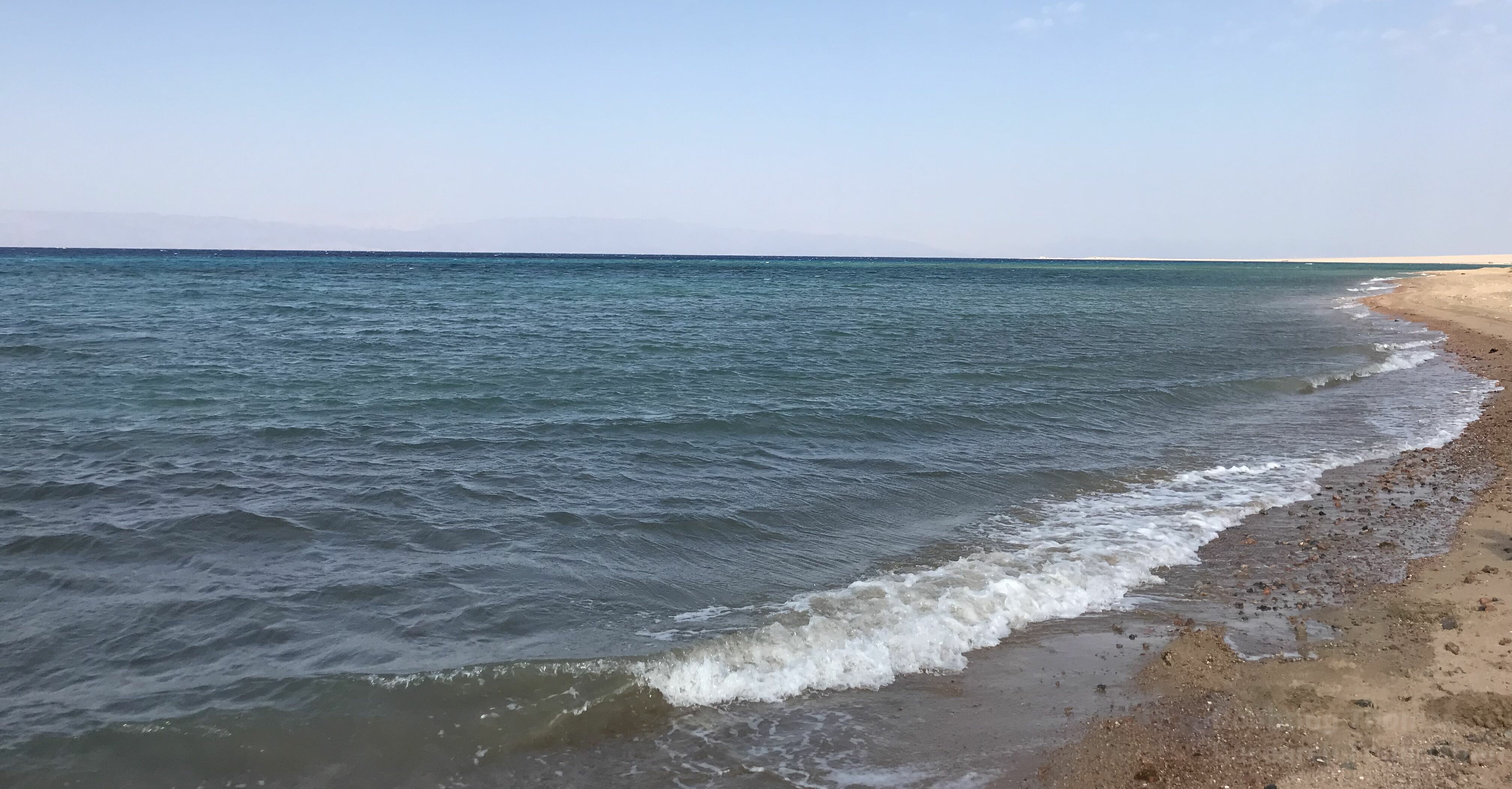
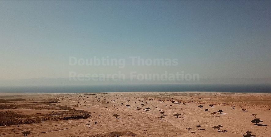
One of the most-favored theories among those who believe Mount Sinai is in Saudi Arabia is that the Red Sea Crossing took place at the Gulf of Aqaba, specifically at Egypt’s Nuweiba Beach, which is located about half-way down the Sinai Peninsula.
Dr. Fritz is a leading contemporary advocate of this site. His research followed the lead of self-styled explorer Ron Wyatt who, in the 1970s, claimed that he identified Nuweiba Beach as the most likely crossing point. Many scholars have dismissed this claim, believing that Wyatt's methodology was unorthodox and not in line with proper scholarship.
The large size and placement of Nuweiba Beach make it distinct to viewers using Google Earth. It is large and flat, and isolated by mountainous terrain on three sides, but is reachable through an indirect, narrow path through the mountains from the northern part of the Sinai Peninsula.
The book of Exodus says that the Israelites crossed at a place where “the wilderness had shut them in” (Exodus 14:3). The 1st-century Jewish historian Josephus clarified that the crossing point was mountainous, which would have trapped the Israelites in on three sides.
Now when the Egyptians had overtaken the Hebrews, they prepared to fight them, and by their multitude they drove them into a narrow place; for the number that pursued after them was six hundred chariots, with fifty thousand horsemen, and two hundred thousand foot-men, all armed. They also seized on the passages by which they imagined the Hebrews might fly, shutting them up between inaccessible precipices and the sea; for there was [on each side] a [ridge of] mountains that terminated at the sea, which were impassable by reason of their roughness, and obstructed their flight; wherefore they there pressed upon the Hebrews with their army, where [the ridges of] the mountains were closed with the sea; which army they placed at the chops of the mountains, that so they might deprive them of any passage into the plain.
Titus Flavius Josephus, Antiquities of the Jews, Book II, chapter 15.
If Nuweiba Beach is the correct crossing point, the Israelites indeed would have been trapped if Pharaoh's army was following them through the Wadi Watir entry to the beach.
Nuweiba Beach is approximately 10.9 square miles large, theoretically providing adequate space for the Israelite population. Dr. Fritz concludes that this is the spot where the Israelites crossed. After studying the Gulf of Aqaba candidates, he concludes:
[T]he Nuweiba beachhead is the only Gulf of Aqaba location geographically suited to the biblical sea crossing in these three aspects:
- Accessible and spacious opposing beachheads with travel routes to or from the interior regions.
- Topographical barriers limiting escape routes from the beachhead encampment.
- Intervening seafloor terrain that exhibits a wide potential path, with mild slopes, and the absence of obvious obstructions.
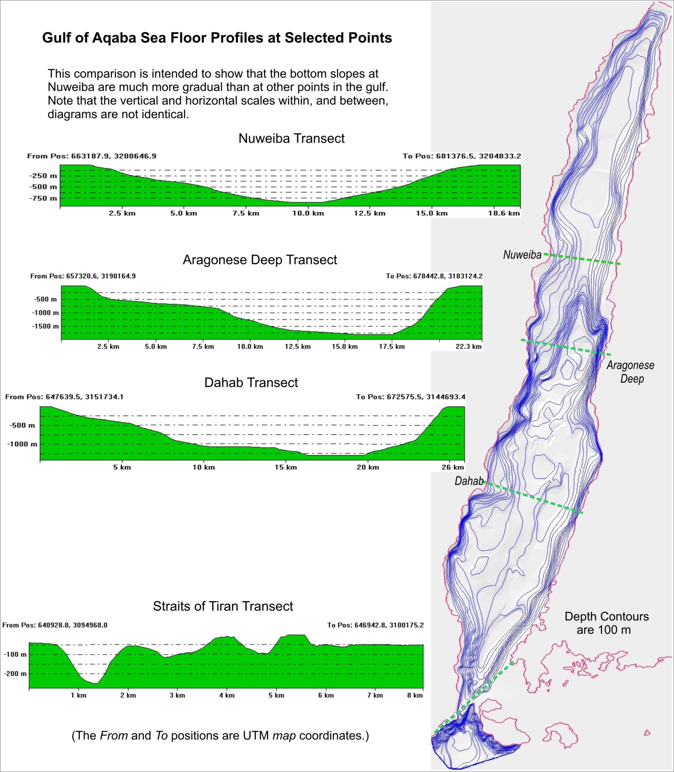
Questions have arisen as to the ability to walk along the land bridge, "Is it feasible for this land bridge be safe enough to walk along?" The most comprehensive analysis was done by Dr. Glen Fritz in his book, "The Lost Sea of the Exodus." His analysis relied upon data from John Hall and Zvi Ben-Avraham of the Geological Survey of Israel (1979) and John Hall independently (2000), which he writes "is the most detailed bathymetry data published for the Gulf of Aqaba." An advanced analysis was then done using that data to calculate the slope. He concluded,
"[N]one of the slope calculations at the Nuweiba crossing would present an insurmountable impediment to foot or wheeled vehicle movement. In fact, the 10.5% average downhill slope on the west is identical to the 10.5% (6 degree) maximum usually allowed for an intestate highway. On the east, the 13% uphill slope is similar to the 12.5% (1:8 or 7.125 degree) wheelchair ramp regulations."
On the opposite shore, the terrain is fairly flat. The Israelites could certainly have traversed over this part of the Arabian shore if they traveled to this point. This location also offers some of the few routes to the ancient city of Midian, according to Dr. Fritz.
Research conducted by Israeli geologists also offers a look at how Nuweiba could have been the crossing point. J.K. Hall and Z. Ben-Avraham of the Israel Geological Survey studied the Gulf's depths and produced a map detailing the seabed depths.
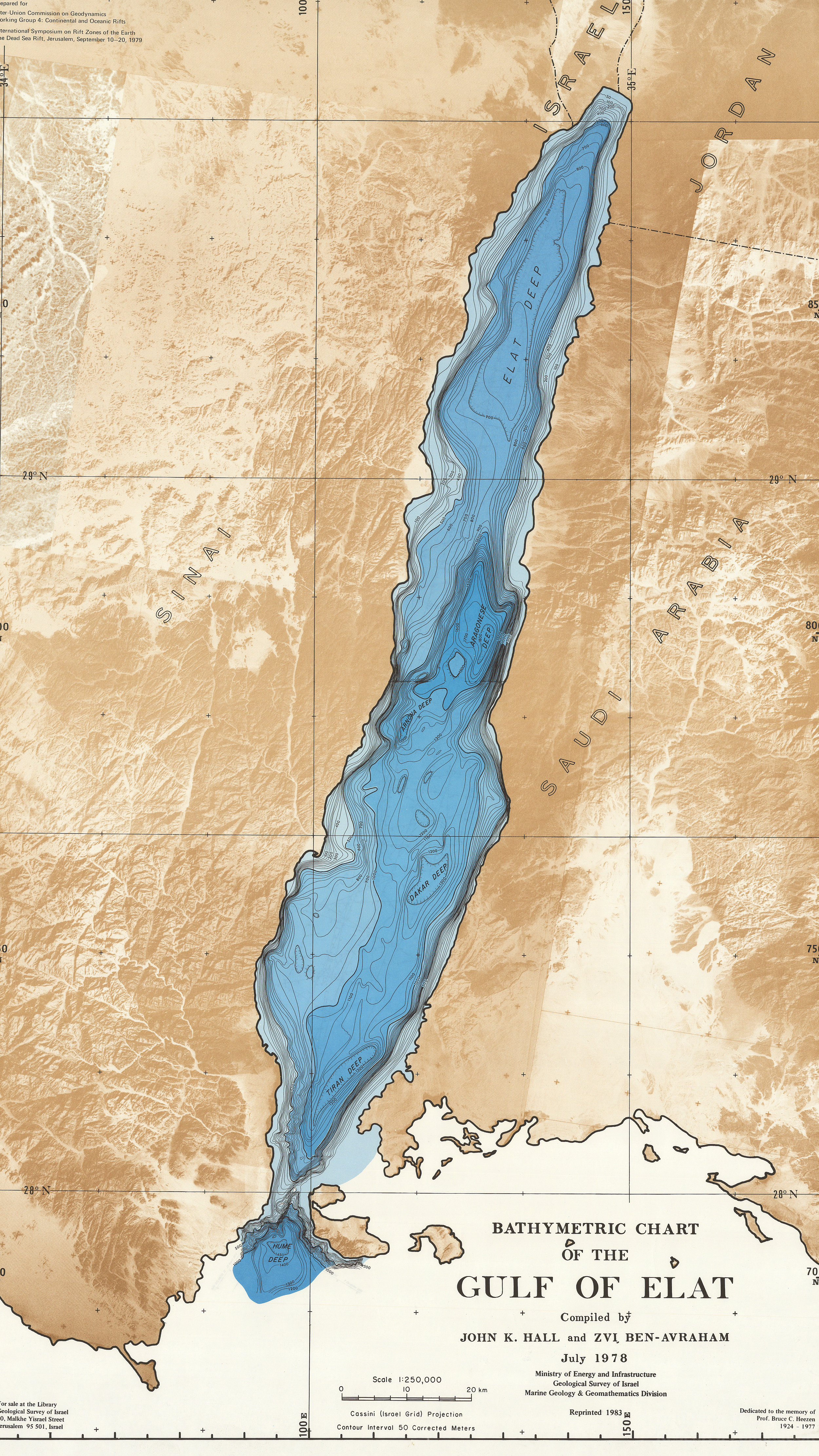
The imaging above shows how there are several very deep points in the Gulf, this being the result of the Gulf's being a part of the Great Rift Valley. But notice how at the Nuweiba coast, the depth is more shallow and the grade is not as steep as other parts of the Gulf.
Here is another map, utilizing the same data, from Dr. Fritz.
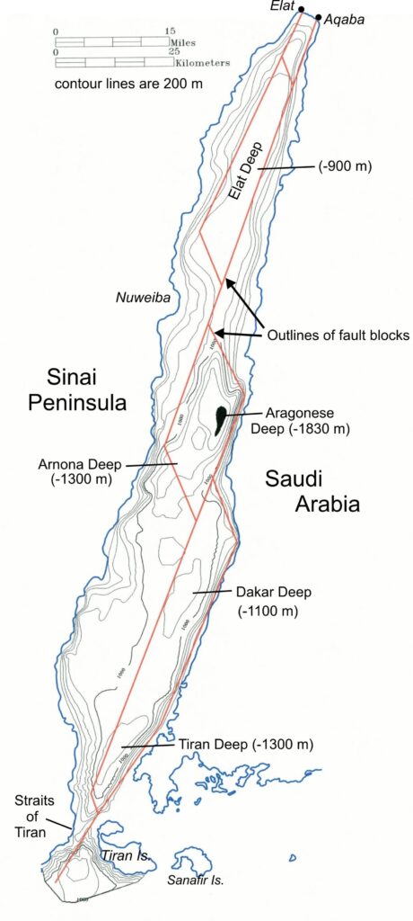
Courtesy of Glen A. Fritz 2019 The Exodus Mysteries: of Midian, Sinai & Jabal al-Lawz
Another study that mapped the underwater topography of the Gulf of Aqaba was conducted by the Marine Geophysics Lab of the National Institute of Oceanography and Fisheries in Alexandria, Egypt. The authors of this study published their findings in the Journal of Geoscience and Environmental Protection. Their paper titled, "Evaluation of the Crustal Features of the Gulf of Aqaba Deduced from Geophysical Data," compiled all available, published data on the Gulf of Aqaba to produce the bathymetric map below. Notice, again, how the topography between Nuweiba beach and the Saudi Arabian shore opposite it gradually slope and meet in the middle.
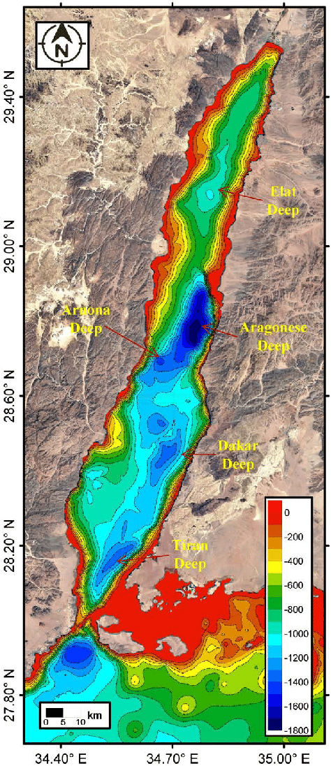
Hamouda, Amr & El-Gharabawy, Suzan. (2019). Evaluation of the Crustal Features of the Gulf of Aqaba Deduced from Geophysical Data. Journal of Geoscience and Environmental Protection. 07. 26-41. 10.4236/gep.2019.74003.
Dr. Lennart Möller, author of The Exodus Case, noted this as well. In chapter 42, he calculated that the approximate grade based on this information would be about 12%. While this may seem like a very steep grade, he also pointed to the fact that this is within the guidelines for wheelchair ramps as required by the Americans with Disabilities Act (between 8.3-12.5%).
A bit on the steep side? Yes. Insurmountable? No.
Alleged Evidence of Pharaoh's Army Along Nuweiba Crossing Point
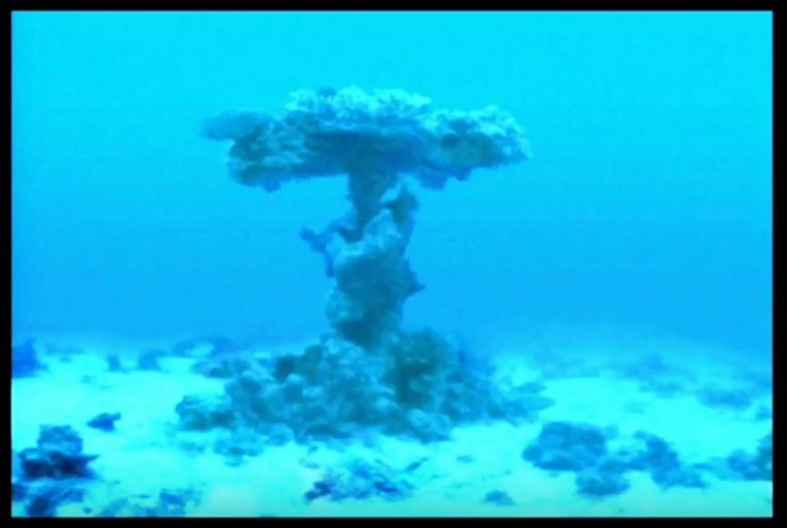
Unprecedented explorations of the seabed along the Nuweiba underwater land path to Saudi Arabia was conducted in the spring of 2001 by Dr. Lennart Möller and a team operating specialized, remote-controlled cameras for videography.
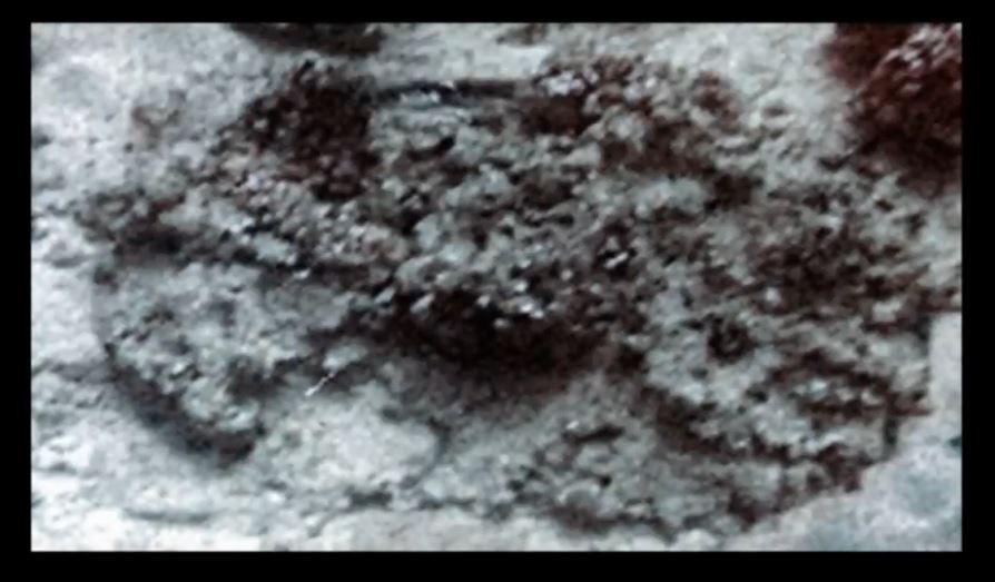
Dr. Möller is a professor of medical sciences in Sweden with an interest in marine biology and archaeology and author of the tome, The Exodus Case. He says that the coral formations are unique from corals in other parts of the world he’s observed. He described the seabed as resembling a “junkyard” with coral formations having 90-degree angles and circular shapes that indicate man-made objects.
He believes that the debris of the Egyptian army became encrusted by the coral, which retained the shape of the objects it grew upon. The most distinct coral formations resemble chariot wheels and chariot cabins. (See the gallery below).
In his book, Möller refers to two coral formations that resemble chariot wheels with six spokes and others with four and eight spokes. He believes these formations support placing the Exodus around 1450 B.C., as that’s the only time where Egypt’s army utilized all three types of chariot wheels. He also points to possible remains of human and horse skeletons, among other coral shapes.
A researcher named Aaron Sen has dived at Nuweiba hundreds of times and has observed the coral shapes. He agrees that the coral formations are unique from other locations with coral that he has seen while diving.
Sen brought a metal detector on own expedition to test some of the formations resembling wheels. He says that the positive readings within the formation are consistent with the shapes of chariot wheels.
There is a strong local tradition within northwest Saudi Arabia of the crossing happening in this general location, including rumors about Saudi officials having found chariot wheels deep in the waters.
Dr. Fritz is more cautionary about linking the finds to the Exodus story because of the great difficulty in proving the connection. It is possible that encrusted chariot wheels and skeletal remains are attributable to shipwrecks or other seaborne activity in the area.
Unfortunately, further research is largely prevented by Egyptian and Saudi regulations. The Egyptian government prohibits the retrieval of coral or underwater objects. The Saudi government is more prohibitive of such explorations in general.
In 2017, Ryan Mauro and associates of the Doubting Thomas Research Foundation visited the Saudi site of the alleged crossing site. Saudi police appeared and prevented any diving in the specific location of most interest. The Saudi police maintained their presence until our researchers left the area.
The Red Sea's Sharm El-Sheikh/Straits of Tiran
Bob Cornuke of the Biblical Archaeology, Search, and Exploration (BASE) Institute proposed a 12-mile crossing from the southern Sinai Peninsula from Sharm El-Sheikh into Saudi Arabia via the Straits of Tiran in the early 1990s.
Cornuke points to a shallow, underwater land path from Egypt into Saudi Arabia and has pictures of him standing in it, demonstrating how Moses and the Israelites could conceivably walk into Saudi Arabia if the waters parted.
The theory is most persuasive when looking at satellite imagery from Google Earth. An overhead view of the terrain shows a possible route heading south along the western side of the Sinai Peninsula, then eastwards towards the crossing point at Sharm El-Sheikh. It visually appears that this route is wide enough to have accommodated the large Israelite population and the Pharaoh's army.
Critics of this theory argue that there is a large gap interrupting the proposed underwater land path. Unless this gap came into existence after the Exodus, the Israelites would not have been able to cross due to this deep gap.
In both The Lost Sea of the Exodus and his latest book, The Exodus Mysteries: of Midian, Sinai, and Jabal al-Lawz, Dr. Glen Fritz addresses this issue by providing graphs showing the underwater terrain for both the Straits of Tiran crossing theory and the Nuweiba Beach crossing theory (as well as a few other lesser proposed crossing sites along Aqaba). One of these graphs can be seen below.
 Courtesy of Glen A. Fritz 2019 The Exodus Mysteries: of Midian, Sinai & Jabal al-Lawz
Proponents have suggested that the gap within the Straits of Tiran (as seen above) may not have existed during the time of the Exodus, as the land may have shifted with tectonic movements. Critics counter that the theory does not align with current knowledge of tectonic plate movements and that there is more rough, up-and-down terrain even after the gap. However, if the proponents are right and later geological activity has caused the rough topography, the Straits of Tiran are then certainly a plausible candidate for the crossing site.
Last updated May 6th, 2020.
What is the mean sea level at this just underwater land bridge?
At what velocity does the water begin to pile up and away fm the area to form dry land? From what direction does the wind need to blow, and does this happen every now and again in this area?
The most comprehensive analysis was done by Dr. Glen Fritz in his book, “The Lost Sea of the Exodus.” His analysis relied upon data from John Hall and Zvi Ben-Avraham of the Geological Survey of Israel (1979) and John Hall independently (2000), which he writes “is the most detailed bathymetry data published for the Gulf of Aqaba.” An advanced analysis was then done using that data to calculate the slope. He concluded, “[N]one of the slope calculations at the Nuweiba crossing would present an insurmountable impediment to foot or wheeled vehicle movement. In fact, the 10.5% average downhill slope on the west is identical to the 10.5% (6 degree) maximum usually allowed for an intestate highway. On the east, the 13% uphill slope is similar to the 12.5% (1:8 or 7.125 degree) wheelchair ramp regulations.”
People seem to forget not to limit our God! When The Great I Am wants it done…it gets done, His way.
Much of what is currently being researched on this site, has already been discovered and proven by Ron Wyatt in the late 1970’s.! In this research, still no mention of the 2 towers built by King Solomon marking the crossing. Yes, it’s Arabia.
My question is: if there was silt and sediment coming down through the wadis in sufficient quantities to form beaches and the massive land bridge, why were any artifacts not long ago totally buried by 3,500 years of accumulating silt and sediment?
We plan on diving at this site at some point in the future. Our last attempt to explore the seabed was thwarted by Saudi police, so there are a lot of questions we can’t answer too thoroughly as of now. We hope that our future trips will offer more evidence about what’s down on the seabed.
Hello Ryan,
I have spent three weeks with this possible area being the actual site; and am quite convinced there appears to be strong biblical and geographical evidences, and with Dr. Lennart Moller’s research the crossing at Nuweiba Beach in the Gulf of Aqaba seems very convincing. The only thing that stumps me is the desert areas. Would this mean that most of the deserts explained in Exodus are farther east than traditionally thought on the Sinai Peninsula? (Shur, Sin, Paran, etc.) The Desert if Shur is quoted after the crossing in Exodus 15:22, and the original place is east of Goshen. Any thoughts of your research about this? Thank you!
Hi Wayne, great question! Our research team just completed some investigation into the location of Shur and published a new page on the subject. Please read our perspective on how it fits into our theory!
https://jabalmaqla.com/wilderness-shur/
Thank you for this information, very valuable!
I understand that Timothy Mahoney the filmmaker of Patterns of Evidence: The Exodus; and Patterns of Evidence: The Moses Controversy plans a Patterns of Evidence film based on the Aqaba crossing. Do you have any information regarding this?
We have heard that Tim Mahoney is working on his next film, and that it will be about the Red Sea crossing, but don’t have more detail than that. We look forward to seeing his next contribution to the Mount Sinai historiography.
very good article , it is an important subject thank you
Ryan Mauro is wrong about the crossing point at Nuweiba. The Hebrews traveled along the western coast of the Sinai peninsula which is a tens of kilometers wide coastal plain of flat sandy beach down to the Southern tip of of the Sinai peninsula at Sharm El-Sheikh. This is the only route and terrain that will accommodate the huge number of Hebrews traveling quickly and Pharaoh’s army with his chariots that later chased after them. The current arabic naming for the crossing place ‘Sharm El-Sheikh’ is a corruption of the Hebrew “Sha’ar El-Sham” which literally translates as “gate of god there”. For more info see here: http://www.bible.ca/archeology/maps-bible-archeology-exodus-route-overview.jpg
http://www.bible.ca/archeology/maps-bible-archeology-exodus-route.jpg
From the Map posted above:
— “Pi Hahiroth” is the Hebrew Pei Hasirot or mouth of the boats. This is exactly what the natural bay at the southern tip of the Sinai would have been, as can be seen on the satellite map I posted above.
— The Arabic “Sharm el Sheikh” is really a corruption of the Hebrew Sha’ar el Sham, meaning Gate [of] God [over] There. This means the crossing occurred there at the tip of the Sinai, at the Straits of Tiran.
— “Etham” is from the Hebrew “etom” meaning closed off or sealed. It is also where English word “Tomb” is derived from. And it is exactly where we expect the place to be.
— Migdol, is right by “Etham”, and translates from the Hebrew as Tower. It is where the Egyptian border guards spotted the Hebrews trapped or sealed by the mountains at “Etham” informing the Pharaoh, who then decided to chase after the Hebrews knowing they are trapped.
— Baal Zaphon translates from the Hebrew is Lord [of the] North, and it is the island guarding the entrance north to the Gulf of Eilat. Today it is known as Tiran Island.
Hi Mika, thanks for your input! There are several things we would say in response to your assertions.
The translation for Pi-Hahiroth appears to rest on an assumption that the ancients understood the Strait to be an opening to another body of water. However, the Gulf of Aqaba was not understood by ancient peoples, and this misunderstanding dominated the historiography until the 1800s (we detail more of this on our maps page. Aqaba has hazardous sailing conditions and it was hardly ever used for sea travel in the ancient world. Since this Gulf was not used to sea travel, and was not even properly understood, we contend that this conclusion is problematic.
Another objection that we maintain is that the terrain at Nuweiba better fits the description from Josephus and Exodus. Both accounts indicate that the mountains surrounded the Israelites on three sides and ended right near the water’s edge, with the only escape route being the wadi they came through. At Tiran, there is a lot more open territory between where the mountains end and where the water begins, not to mention several wadis by which the Israelites may have been able to escape, including the shoreline up the Gulf of Suez. At Nuweiba, the Israelites would have been clearly trapped with mountains on all three sides and the sea in front of them. Tiran appears to be too open to us to fit these descriptions.
Of course, we are open to new information and will examine new evidence as it comes our way.
As well as possible!
MANY THANK TO YOU
THANK YOU VERY MUCH
thank you very much and very good
great write up! I like that you included other researchers that came after Ron Wyatt (which increases his credibility). I never met him, but I am so grateful for Ron Wyatt’s heart which God used to discover these things. Also love your heart and your website. Keep up the great work!