Key Biblical Locations That Point to Mount Sinai in Saudi Arabia
The Exodus narrative and Torah overall documents each stage of the Israelites' journey from Egypt to Mount Sinai, through the 40 years of wilderness wanderings, all the way to the conquest of the promised land by Joshua. Some interpretations of where these events took place have led to the conclusion that Mount Sinai is in Egypt’s Sinai Peninsula. However, an Arabian location for Mount Sinai is certainly plausible and, in fact, much more likely when these Biblical locations are mapped out.
Kadesh-Barnea
Kadesh was one of the stages of the Exodus journey just before and after the Israelites defied God's command to take the Promised Land the first time they encountered it. They were subsequently sentenced to 40 years of wandering in the wilderness.
Deuteronomy 1:2 states that Kadesh was an eleven-day journey from Mount Sinai by the way of Mount Seir. Many Bible maps place Kadesh at what is currently Tell el-Qudeirat.
One of the objections to the Arabian location for Mount Sinai is that ancient peoples could not have made a trip from Jabal Maqla to Tell el-Qudeirat in an eleven-day time period. If Tell el-Qudeirat is Biblical Kadesh, then an Arabian location could possibly be challenged based on the distance.
However, what if a widely accepted fact about Kadesh’s location is incorrect? What if Kadesh was actually in another location? Based on ancient Christian and Jewish sources, we believe that Tell el-Qudeirat may not be the true Kadesh-Barnea, one of the key locations that aids in identifying Mount Sinai. There are two primary reasons for our assertion.
Kadesh within the Promised Land?
Tell el-Qudeirat is located approximately 27 kilometers east of Wadi el-Arish, or the River of Egypt. This geographic feature is one of the boundaries of the land which God promised to Abraham’s descendants in Genesis 15:18.
On that day the Lord made a covenant with Abram and said, “To your descendants I give this land, from the Wadi of Egypt to the great river, the Euphrates…”
Joshua 15:2-4 also defines the Wadi as Israel’s southern boundary marker.
Their southern boundary started from the bay at the southern end of the Dead Sea, crossed south of Scorpion Pass, continued on to Zin and went over to the south of Kadesh Barnea. Then it ran past Hezron up to Addar and curved around to Karka. It then passed along to Azmon and joined the Wadi of Egypt, ending at the Mediterranean Sea. This is their southern boundary.
The order in which the southern boundary is marked appears to go from east to west, from the Dead Sea, towards the south, then all the way west to the Wadi of Egypt and the Mediterranean.
Czech explorer Alois Musil also pointed this out during his study of the region.
Kades, although it is mentioned so many times in the Pentatecuh, is never included among the localities or cities of Palestine. The account just cited shows that the city of Kades lay on the very borders of the Promised Land and of Edom and, as we know from other records, at the western foot of Mount Se’ir, which, as has frequently been stated already, extended to the south-southeast of the Dead Sea. We must not, therefore, locate Kades either to the southwest or to the south but to the southeast of the Promised Land; this, moreover, tallies with the situation in the environs of Petra which we have suggested. To the west of the latter is the watershed of al-‘Araba, and near it the frontier of Palestine probably passed westward to the valley of Egypt and the Mediterranean Sea. The border of the Promised Land led along the western side of al-‘Araba, which at its northern extremity belonged to Moab, and farther south to Edom.
Alois Musil, The Northern Hegaz: A Topographical Itinerary (New York: American Geographical Society, 1926), 265.
Based on the boundaries laid out in Scripture, Tell el-Qudeirat is within the bounds of the Promised Land. Aside from the 12 Israelite spies just prior to the 40 years of wandering, the Israelites did not step foot into this land until Joshua led them across the River Jordan. Therefore, how could this spot be Kadesh?
Where is the Real Kadesh-Barnea?
Even the most well-read Biblical scholars are not 100% sure of Kadesh’s true location. It’s been somewhat of a mystery for many centuries, but there are some guideposts we can use to determine an approximation.
In the book of Genesis, Abraham lived near the ancient site of Kadesh for a time during his days in Canaan.
Now Abraham moved on from there [near Sodom] into the region of the Negev and lived between Kadesh and Shur. – Genesis 20:1
As we show on our page identifying the Wilderness of Shur, this area was in Midianiate territory in northwestern Saudi Arabia. Some Biblical maps identify Shur in Egypt’s Sinai Peninsula. However, Abraham did not live in the Sinai Peninsula region at this time, but in the Negev area, specifically what we now know to be the Arabah Valley.
Numbers 20:1 states that the Israelites stayed at Kadesh and it was here that Miriam died and was buried.
Then the sons of Israel, the whole congregation, came to the wilderness of Zin in the first month; and the people stayed at Kadesh. Now Miriam died there and was buried there.
After 30 days of mourning, the Israelites made a short journey from Kadesh to Mount Hor, where Aaron died and was buried.
The Jewish historian Josephus wrote in The Antiquities of the Jews that Kadesh-Barnea was a relatively short distance from the Arabian capital city of Petra during his day.
Now when this purification [for Miriam], which their leader made upon the mourning for his sister, as it has been now described, was over, he caused the army to remove and to march through the wilderness and through Arabia; and when he came to a place which the Arabians esteem their metropolis, which was formerly called Arce, but has now the name of Petra, at this place, which was encompassed with high mountains, Aaron went up one of them in the sight of the whole army, Moses having before told him that he was to die, for this place was over against them.
Titus Flavius Josephus, “Book 4, Chapter 4: What Happened To The Hebrews During Thirty Eight Years In the Wilderness,” in The Antiquities of the Jews (93)
Eusebius of Caesarea also placed Kadesh at, or in close proximity to, Petra.
Kadea Barne. The desert which extends to (the city of) Petra a city of Arabia. There Mariam went up and died, and there the doubting Moses struck the rock to give water to the thirsty people. The tomb of Mariam herself is pointed out there even now. There also Chodollagomor beat the chiefs of the Amalakites.”
Eusebius of Caesarea, “The Onomasticon,” Section K, Footnote 580.
Kadesh and Petra appear to be a very short distance from each other according to these accounts. Since Petra is in Transjordan, it would not have been a short trip from Tell el-Qudeirat, but may have taken several days at least. As the crow flies, the distance is nearly 120 kilometers.
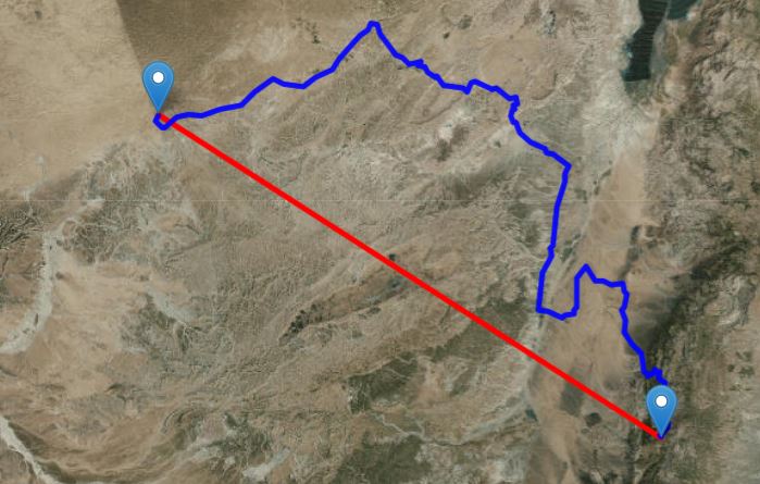
Depending on the terrain, ancient peoples could travel about 10-18 miles per day, based on several estimates. From Kadesh to Petra, this would mean an approximately 12-day journey if the Israelites were traveling in a straight line. But of course, hardly any journey is so simple.
The Negev Desert is full of rough terrain that would make a journey to Petra far more than a few strides. But Numbers 20 and 33 both indicate that there were no middle stages between Kadesh and Mount Hor.
Now when they set out from Kadesh, the sons of Israel, the whole congregation, came to Mount Hor. – Numbers 20:22
They journeyed from Kadesh and camped at Mount Hor, at the edge of the land of Edom. – Numbers 33:37
It’s difficult to accept the theory that the Israelites traveled from a location far to the west (and within the Promised Land) all the way east to Mount Hor, by Petra, and for the author, Moses, to make no mention of any stops on that long journey.
Moses carefully documented each of the stages of the entire journey; skipping over that large a portion of time and travel does not fit with the pattern of the text.
Alois Musil also identified Kadesh-Barnea near Petra in the early 20th-century. In his book The Northern Hegaz: A Topographical Itinerary, he states that Deuteronomy’s mention of the road to Seir indicates that Kadesh had to be in the territory that the Nabataeans later controlled.
This road passes through a great and terrible wilderness; but Mount Se’ir was cultivated and inhabited, and it must therefore be supposed that the road in question passed along its western foot on the border between Se’ir and Paran. In that district there is actually an ancient transport route leading from Madian through the valley of al-Abjaz past Mount Iram (Ramm) and the ruins of al-Homejma northward to the ruins of Petra, then farther through the convenient an-Namala pass to the right valley of al-‘Araba, and in a northwesterly direction to Hebron, or in a west-northwesterly direction to Gaza. This road, upon which in the Nabataean period the main import trade from the south to Petra and Gaza was concentrated, may thus be identified as the road to Mount Se’ir, and the road to the mountain of the Amorites. If the Israelites passed along it, then they reached the actual wilderness of Paran via the modern ruins of al-Homejma. We must therefore seek Kades [Kadesh] in the neighborhood of Pertra. From there could be seen the mountain of the Amorites and the Promised Land, a circumstance which explains why the spies were sent out to report as to the manner in which the Israelites could obtain possession of the latter.
Alois Musil, The Northern Hegaz, 270-271.
Musil also stated that the Israelites could not have entered the Promised Land through a northwesterly route because the Amalekites and Canaanites were there in preparation for them, and thus they would have entered the Promised Land by traveling around the Dead Sea and crossing the Jordan River heading West.
According to this account, Kades was a city on the borders of Edom, from which it was easy to reach the royal highway passing through the land of Edom from south to north. This tallies with the vicinity of Petra, which is at the western slope of the Se’ir range and thus on the western border of Edom. Through Petra leads a convenient transport route from south to north, and by way of the an-Namala pass there is another route to the west and northwest. This pass was and still is connected by means of the ancient transport route with the settlement of Ma’an, situated on the great trade route from southwestern Arabia northward to Phoenecia and Damascus.
Alois Musil, The Northern Hegaz, 264.
In order to get to the Promised Land by this route, the Israelites had to request permission from the king of Edom. At this time, Petra was within the Edomite borders, in the eastern part of the kingdom. Numbers 20 recounts how the Israelites attempted to cross through this region by the “king’s highway,” but the Edomite king met them in force and the Israelites had to turn aside to Mount Hor, on the border of the Edomite territory.
Based on the route that Moses and the Israelites took after being turned away by the king of Edom, Musil postulated that they must have traveled southward toward the Red Sea (Yam Suph - or - the Sea of Reeds as some wrongly call it), which further solidifies the assertion that Kadesh must have been at or near Petra.
The accounts quoted above [Numbers 20:19, 21:4; Deuteronomy 1:2, 19; 2:1, 4, 8] concerning the journey along Mount Se’ir from Kades southward to the Sea of Reeds and thence along the ‘Araba highroad across the southwestern corner of Se’ir to the northeast and north, agree entirely with the present routes. They thus corroborate our supposition that Kades must be located in the vicinity of Petra.
Alois Musil, The Northern Hegaz, 265.
Musil also identified Mount Hor with the modern-day Mount Haroun, south of the ruins of Petra.
How does this relate to an Arabian location for Mount Sinai?
Recall that Deuteronomy Chapter 1 locates Kadesh-Barnea as an eleven-day journey from Mount Sinai by the way of Mount Seir. As the crow flies, the distance from Jabal Maqla to Petra is about 188 kilometers, or 117 miles.
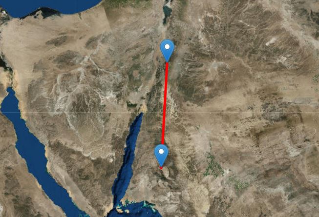
On the contrary, from the traditional site in the southern Sinai Peninsula, the distance is almost 250 kilometers, or 154 miles. Not only is the distance longer, but this site is also in the heart of the wilderness, and is much further away from any ancient roads than Jabal Maqla (as the ancient city of Midian is a short distance from this mountain). This fact would have made this journey even longer than regular road travel.
However, even if one locates Kadesh-Barnea at modern-day Tell el-Qudeirat, an Arabian Mount Sinai certainly does not necessarily become implausible.
From Jabal Maqla to Tell el-Qudeirat, the total distance is 268 kilometers, or 166 miles. A further distance, yes, but not completely impossible.
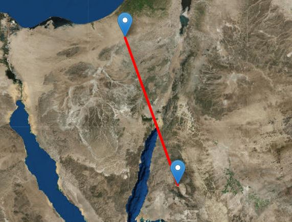
Though distance may not necessarily be an insurmountable barrier, it is our position that Tell el-Qudeirat cannot be Kadesh because, as stated previously, it is within the boundaries of the Promised Land as laid out in Scripture.
Based on the above information, it is our position that Kadesh-Barnea was in very close proximity to Petra. Its true location is still somewhat obscure because of the amount of time that has passed, but with Josephus’ and Eusebius’ accounts, the Biblical accounts, and mapping of the locations, we maintain this key Biblical location points to Mount Sinai in Saudi Arabia.
Ezion-Geber on the Red Sea
Several hundred years after the Exodus, under the reign of King Solomon, Israel’s territory and wealth greatly increased. Foreign leaders came from all over the known world to honor Solomon and seek out his wisdom.
As a part of Israel’s time of prosperity and peace, Solomon built many new cities in the land, and even raised a navy at sea. Solomon constructed his naval fleet at Ezion-Geber, which the book of 1 Kings states was on the Red Sea (again, literally, Yam Suph). Chapter 9 verses 26-27 state:
King Solomon also built a fleet of ships in Ezion-geber, which is near Eloth on the shore of the Red Sea, in the land of Edom. And Hiram sent his servants with the fleet, sailors who knew the sea, along with the servants of Solomon.
Ezion-Geber was an ancient location at the kingdom of Israel’s southernmost border at the sea. Eloth was a city in close proximity to Ezion-Geber, and modern-day Eilat is close to this ancient city’s location.
The author of 1 Kings clearly names this body of water upon which the fleet was built as the Red Sea, or Yam Suph. This further strengthens the theory that the sea the Israelites crossed several hundred years earlier was not a landlocked lake or a swampy, shallow body of water closer to Egypt but, rather, the Gulf of Aqaba.
In The Miracles of Exodus: A Scientist’s Discovery of the Extraordinary Natural Causes of the Biblical Stories, Dr. Colin Humphreys writes:
Presumably the wise Solomon would not have built his ships on an inland reedy lake, since he would not have been able to get them out! The precise locations of ancient Elath and Ezion Geber are uncertain, although many scholars believe that Elath was in, or close to, modern Aqaba in Jordan, on the northeast side of the head of the Gulf of Aqaba. However, we do know that ancient Edom was a country adjacent to the Gulf of Aqaba, hence we can say with reasonable certainty that the biblical yam suph is the Gulf of Aqaba, which is one arm of the Red Sea (the other arm being the Gulf of Suez). Yam suph may refer to other bodies of water as well, but I suggest that it is beyond reasonable doubt that the biblical yam suph includes the Gulf of Aqaba.
In our section discussing issues with many modern theories about the Red Sea Crossing, we note the fact that the "Sea of Reeds" designation for Yam Suph has caused much confusion as to the sea’s true location. However, based on additional research from Dr. Humphreys, this does not need to be a point of contention in identifying the Gulf of Aqaba as Yam Suph of the Exodus.
Dr. Humphreys writes that the Gulf of Aqaba is a unique body of water. The Red Sea is a saline body of water, and reeds tend to not grow in salty water. However, there is a strange phenomenon at the northern part of the Gulf, as observed by one explorer in the early 20th century.
The Czech explorer Alois Musil, in The Northern Hegaz, written in 1926, describes an extremely unusual feature of the northern seashore at the head of the Gulf of Aqaba: it contains fresh water. He writes: “At low tide the rocky shore was laid bare for a distance of about two hundred yards, uncovering numerous springs which gushed forth with great strength.” Musil then emphasises the excellent quality of this fresh water: “The animals [camels] did not wish to drink from the fresh water from the well, preferring to go to the sea shore where they very readily drank from the many springs which flowed there.”
What is the origin of the water in these freshwater springs at the head of the Gulf of Aqaba? It comes from rain water falling on the mountains bordering the Arabah. The water is then funnelled along and under the sand of the Arabah down towards the Gulf of Aqaba, where it breaks out on the seashore as freshwater springs.
(For more on the Red Sea Crossing, please visit our page dedicated exclusively to the topic).
The claim that Yam Suph refers to a marshy, shallow body of water in the vicinity of the Nile delta or the Egyptian domain is highly questionable considering these facts. Solomon would not have made a fleet on a body of water that did not offer access to the open ocean; that is simply a matter of basic sense. The Gulf of Aqaba offered Solomon’s fleet access to the Indian Ocean and the various sea trading routes in that part of the world, whereas the other proposed locations simply would not.
Solomon would not have built his fleet in Egyptian waters, at the Gulf of Suez, either. The 1 Kings account records Ezion-Geber as being in the realm of Edom, not Egypt. The only body of water that fits these criteria is the Gulf of Aqaba.
We have some geological evidence for this location, as well. Translated from Hebrew, Ezion-Geber means “strong-backbone.” Dr. Glen Fritz, in his book The Lost Sea of the Exodus, claims that the best conclusion one can make based on the Biblical geography is that this name referred to the mountain range just northeast of the Gulf of Aqaba’s tip (95).
In this area the mountain ridge roughly resembles a backbone. Almost directly north of this site is the Arabah Valley and the southern portion of modern Israel. In Dr. Fritz’s scholarly opinion, Ezion-Geber was not a city, but rather a landmark. Given the Hebrew name for the location, and the topography at the tip of the Gulf of Aqaba, this appears to fit with the rest of the Exodus account.
With these things in mind, the Red Sea upon which Solomon built his fleet is likely the same Red Sea the Israelites crossed when fleeing Pharaoh’s army. The implication is that the Red Sea which the Israelites crossed is the Gulf of Aqaba, and that this Biblical location points to an Arabian Mount Sinai.
Last updated January 30, 2022.
Traveltime: At page https://jabalmaqla.com/mount-sinai-red-sea-journey-bible-timeframe/ is written that the Golf of Agaba can be reached from Egypt within 3 days and nights.
At this page is written that they would need 12 days to get from Kadesh to Petra. This is strange reasoning.
Alois Musil: Maybe Musil is maybe not a good reference for the statements about the southern border of the promised land.
At page https://blog.bibleplaces.com/2015/10/ you can read that according to Musil map and identification the southern border is about the same as at the map from Edward Wilton, see figure 2a at page https://ancientexodus.com/exodus-synopsis/ Here the border is about 50-60 km more north then suggested by the Petra for Kadesh alternative. As you say Petra was within the Edomite border, Israel was not allowed to enter. Kadesh is on the maps of Musil and Wilton south of the border in Egypt. I doubt the Hebrew bible description of the border conflicts with the border on these maps. The distance from the wilderness of Paran to the edge of Edom could be a day travel.
About Miriams dead: During the time they were in Kadesh for almost 38 years, Miriam died, the bible does not say when. Shortly (Num 20 and Judges 11) after they came in Kadesh Moses send messengers to Edom to get access through the Kings Highway and to Moab for access through the Jordan valley. It was not allowed, so they stay in Kadesh. The bible does not say that after 30 days of mourning for Miriam they move to mount Hor, this happened at the end of the 38 years.
Perhaps Egypt and Saudi Arabia could open up a guided and monitored Exodus trail and tour from the Nuweibaa beach, over the Gulf of Aqaba and to Mount Sinai (Jabal Maqla). This could allow people to some extent experience what the Hebrews experienced all those years ago.
I’m appreciate this website very much.
I truely hope these sites are preserved and that more archeaological work, perhaps in the sea also, can be done to help people see that the events happened just as it has been recorded. Either way the evidence provided already convinces me and shows a clear pattern that Jabal Maqla is Mount Sinai and the on route sites can be clearly seen.
Stumbled across ur info by accident- im a dinosaur, computer illiterate. Plz send info of ur work! I found story & DVD in mag 10yrs ago that proved real Saudy location of Horeb & R. Sea crossing complete w pics of chariots & bones. V. Much want to keep apprised of ur work! POB 4 Belgrade Mt 59714. BLESSINGS! GRACE & PEACE. R.C. buck Lentz
We love your content. Regards from Pissouri Bay Divers from Cyprus!